IMAGES TAKEN NEAR TO
Black Horse Close, BARNSLEY, S75 4SB
Introduction
This page details the photographs taken nearby to Black Horse Close, S75 4SB by members of the Geograph project.
The Geograph project started in 2005 with the aim of publishing, organising and preserving representative images for every square kilometre of Great Britain, Ireland and the Isle of Man.

There are currently over 7.5m images from over14,400 individuals and you can help contribute to the project by visiting https://www.geograph.org.uk
Image Map (Loading...)


Getting Data...Please wait
Leaflet Map data © OpenStreetMap
Images are licensed for reuse under creativecommons.org/licenses/by-sa/2.0
Notes
- Clicking on the map will re-center to the selected point.
- The higher the marker number, the further away the image location is from the centre of the postcode.
Image Listing (77 Images Found)
Images are licensed for reuse under creativecommons.org/licenses/by-sa/2.0
Image
Details
Distance
2

Pyracantha hedge
Not difficult to see why this is called firethorn!
Image: © Jonathan Thacker
Taken: 29 Sep 2017
0.05 miles
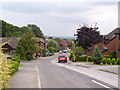
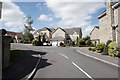
3
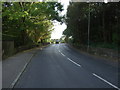
Knabbs Lane (B6449)
Heading south towards Oxspring.
Image: © JThomas
Taken: 3 Oct 2014
0.06 miles
5
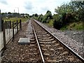
This Line for Penistone
From Silkstone Common Station.
Image: © John Fielding
Taken: 16 Jul 2007
0.06 miles
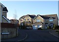
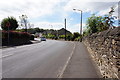
7
Stonecroft Court off Knabbs Lane, Silkstone Common
Image: © Ian S
Taken: 24 Aug 2016
0.06 miles
8
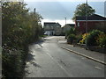
Cone Lane, Silkstone Common
Runs beside the railway.
Image: © JThomas
Taken: 3 Oct 2014
0.07 miles
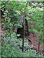
10
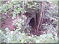
The mouth of the closed railway tunnel under Knabbs Lane at Silkstone
Image: © Martin Speck
Taken: 8 Aug 2010
0.07 miles