IMAGES TAKEN NEAR TO
South Yorkshire Buildings, BARNSLEY, S75 4RJ
Introduction
This page details the photographs taken nearby to South Yorkshire Buildings, S75 4RJ by members of the Geograph project.
The Geograph project started in 2005 with the aim of publishing, organising and preserving representative images for every square kilometre of Great Britain, Ireland and the Isle of Man.

There are currently over 7.5m images from over14,400 individuals and you can help contribute to the project by visiting https://www.geograph.org.uk
Image Map
Images are licensed for reuse under creativecommons.org/licenses/by-sa/2.0
Notes
- Clicking on the map will re-center to the selected point.
- The higher the marker number, the further away the image location is from the centre of the postcode.
Image Listing (39 Images Found)
Images are licensed for reuse under creativecommons.org/licenses/by-sa/2.0
Image
Details
Distance
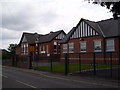
1
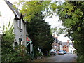
South Yorkshire Buildings, Silkstone Common
Built by the South Yorkshire Coal and Iron Company in 1877 to house workers in nearby pits.
Image: © Jonathan Thacker
Taken: 29 Sep 2017
0.03 miles
3
Railway bridge southeast of Silkstone Common
The railway is long gone, the trackbed and bridge now being used by the Dove Valley Trail
Image: © John Slater
Taken: 23 Nov 2012
0.09 miles
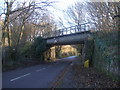
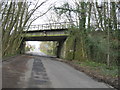
4
Former Railway Bridge at Moor End
Looking northwestward.
Image: © Peter Wood
Taken: 9 Aug 2015
0.09 miles
5
Old railway bridge over Moorend Lane
Low former Railway bridge now carrying Trans Pennine Trail over Moorend Lane, Silkstone Common, looking north-west towards village
Image: © Arthur Fisher
Taken: 19 Mar 2020
0.09 miles
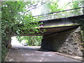
6
Bridge over Moorend Lane
This bridge once carried the Silkstone West to Wombwell Junction railway line. This was one of the steepest gradients on a British railway. The noise of four locomotives getting a loaded coal train up the bank to Penistone must have been terrific.
Image: © Jonathan Thacker
Taken: 29 Sep 2017
0.10 miles
7
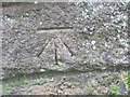
Ordnance Survey Cut Mark
This mark can be found on the former railway bridge.
For more detail see : http://www.bench-marks.org.uk/bm44395
Image: © Peter Wood
Taken: 1 Aug 2012
0.10 miles
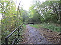
8

Former railway line crossing House Carr Lane
Once a major trans-pennine freight railway. Now part of both the Trans Pennine Trail and the Dove Valley Trail.
Image: © Christine Johnstone
Taken: 2 Feb 2013
0.11 miles
10
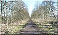
Trans Pennine Trail, east of House Carr Lane
Once a major freight railway across the Pennines.
Image: © Christine Johnstone
Taken: 2 Feb 2013
0.13 miles