IMAGES TAKEN NEAR TO
Moor End Lane, BARNSLEY, S75 4QT
Introduction
This page details the photographs taken nearby to Moor End Lane, S75 4QT by members of the Geograph project.
The Geograph project started in 2005 with the aim of publishing, organising and preserving representative images for every square kilometre of Great Britain, Ireland and the Isle of Man.

There are currently over 7.5m images from over14,400 individuals and you can help contribute to the project by visiting https://www.geograph.org.uk
Image Map
Images are licensed for reuse under creativecommons.org/licenses/by-sa/2.0
Notes
- Clicking on the map will re-center to the selected point.
- The higher the marker number, the further away the image location is from the centre of the postcode.
Image Listing (73 Images Found)
Images are licensed for reuse under creativecommons.org/licenses/by-sa/2.0
Image
Details
Distance
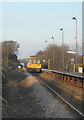
1
Cone Lane Junction
From Silkstone Common Railway Station platform.
Image: © John Fielding
Taken: 16 Jul 2007
0.06 miles

4

Cone Lane Railway Bridge
From Cone Lane, the train is heading for Dodworth to the left of photo.
Image: © John Fielding
Taken: 9 May 2007
0.09 miles
10
Silkstone Common station
A train leaves the station on its way to Dodworth, Barnsley and - ultimately - Sheffield.
Image: © Chris Yeates
Taken: 28 Jan 2006
0.10 miles