IMAGES TAKEN NEAR TO
Barnsley Road, BARNSLEY, S75 4NG
Introduction
This page details the photographs taken nearby to Barnsley Road, S75 4NG by members of the Geograph project.
The Geograph project started in 2005 with the aim of publishing, organising and preserving representative images for every square kilometre of Great Britain, Ireland and the Isle of Man.

There are currently over 7.5m images from over14,400 individuals and you can help contribute to the project by visiting https://www.geograph.org.uk
Image Map
Images are licensed for reuse under creativecommons.org/licenses/by-sa/2.0
Notes
- Clicking on the map will re-center to the selected point.
- The higher the marker number, the further away the image location is from the centre of the postcode.
Image Listing (4 Images Found)
Images are licensed for reuse under creativecommons.org/licenses/by-sa/2.0
Image
Details
Distance
1
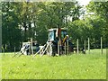
Pile Driving Wooden Fence Posts
In Noble Thorpe Park Silkstone
Image: © John Fielding
Taken: 3 May 2007
0.19 miles
2

Speckled Wood butterfly
A common butterfly of wooded areas.
Image: © John Fielding
Taken: 3 May 2007
0.22 miles
3
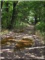
Woodland footpath near Silkstone
Public footpath through strip of woodland to south of Silkstone village.
Image: © Samantha Waddington
Taken: 27 Aug 2011
0.24 miles
4
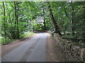
Blackergreen Lane between the A628 and Blacker Dam
Looking south-westward.
Image: © Peter Wood
Taken: 9 Jul 2018
0.24 miles