IMAGES TAKEN NEAR TO
Elmhirst Lane, BARNSLEY, S75 4LD
Introduction
This page details the photographs taken nearby to Elmhirst Lane, S75 4LD by members of the Geograph project.
The Geograph project started in 2005 with the aim of publishing, organising and preserving representative images for every square kilometre of Great Britain, Ireland and the Isle of Man.

There are currently over 7.5m images from over14,400 individuals and you can help contribute to the project by visiting https://www.geograph.org.uk
Image Map
Images are licensed for reuse under creativecommons.org/licenses/by-sa/2.0
Notes
- Clicking on the map will re-center to the selected point.
- The higher the marker number, the further away the image location is from the centre of the postcode.
Image Listing (8 Images Found)
Images are licensed for reuse under creativecommons.org/licenses/by-sa/2.0
Image
Details
Distance
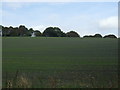
1
At Silkstone Golf Club
With the club house half-hidden in the trees. The bell is dedicated to the memory of a former member now deceased.
Image: © Neil Theasby
Taken: 12 Aug 2021
0.07 miles
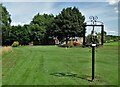
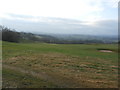
2
Silkstone Golf Course
Looking from the public footpath beside the clubhouse across one of the greens to a lake, one of several water hazards on this course.
Image: © Graham Hogg
Taken: 12 Mar 2012
0.08 miles
3
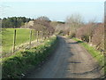
Approaching Anchor Farm
Track and public footpath to the north of Silkstone Golf Course.
Image: © Graham Hogg
Taken: 12 Mar 2012
0.12 miles

5
Footpath Crossing Silkstone Golf Course
Image: © Jonathan Clitheroe
Taken: 8 Feb 2017
0.15 miles
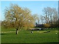
6
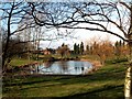
Silkstone Golf course pond and Clubhouse
From the footpath to Silkstone Falls.
Image: © John Fielding
Taken: 7 Feb 2008
0.17 miles