IMAGES TAKEN NEAR TO
South Lane, BARNSLEY, S75 4EE
Introduction
This page details the photographs taken nearby to South Lane, S75 4EE by members of the Geograph project.
The Geograph project started in 2005 with the aim of publishing, organising and preserving representative images for every square kilometre of Great Britain, Ireland and the Isle of Man.

There are currently over 7.5m images from over14,400 individuals and you can help contribute to the project by visiting https://www.geograph.org.uk
Image Map (Loading...)


Getting Data...Please wait
Leaflet Map data © OpenStreetMap
Images are licensed for reuse under creativecommons.org/licenses/by-sa/2.0
Notes
- Clicking on the map will re-center to the selected point.
- The higher the marker number, the further away the image location is from the centre of the postcode.
Image Listing (6 Images Found)
Images are licensed for reuse under creativecommons.org/licenses/by-sa/2.0
Image
Details
Distance
1
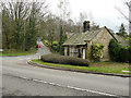
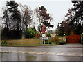
Toll Bar Cottage, Cawthorne
This mid-19C cottage is listed, Grade II. The lane to the left is Dog Kennel Hill.
Image: © Humphrey Bolton
Taken: 14 Mar 2020
0.09 miles
2
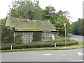
Old Toll House by Lane Head Road, Tivy Dale
Dog Kennel Toll House by the A635, in parish of Cawthorne (Barnsley District), Toll Bar Cottage, Lane Head Road, Tivy Dale, S75 4ED.
Grade II listed.
List Entry Number: 1192214 https://historicengland.org.uk/listing/the-list/list-entry/1192214
Surveyed
Milestone Society National ID: YS.CAW
Image: © Alan Rosevear
Taken: 23 Sep 2012
0.10 miles
3
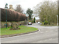
Tivy Dale, Cawthorne
This is the former main road through the village.
Image: © Humphrey Bolton
Taken: 14 Mar 2020
0.11 miles
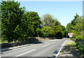
4
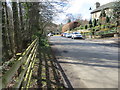
Tivy Dale in Cawthorne
Looking south-westward towards the A635
Image: © Peter Wood
Taken: 25 Mar 2018
0.14 miles
5
A635 junction near Cannon Hall Cawthorne
Image: © Steve Fareham
Taken: 29 Feb 2008
0.17 miles
6
The turning for Cannon Hall off the A635, Cawthorne
Image: © Humphrey Bolton
Taken: 28 May 2020
0.20 miles