IMAGES TAKEN NEAR TO
North Lanes, BARNSLEY, S75 4AH
Introduction
This page details the photographs taken nearby to North Lanes, S75 4AH by members of the Geograph project.
The Geograph project started in 2005 with the aim of publishing, organising and preserving representative images for every square kilometre of Great Britain, Ireland and the Isle of Man.

There are currently over 7.5m images from over14,400 individuals and you can help contribute to the project by visiting https://www.geograph.org.uk
Image Map
Images are licensed for reuse under creativecommons.org/licenses/by-sa/2.0
Notes
- Clicking on the map will re-center to the selected point.
- The higher the marker number, the further away the image location is from the centre of the postcode.
Image Listing (6 Images Found)
Images are licensed for reuse under creativecommons.org/licenses/by-sa/2.0
Image
Details
Distance
1
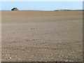
Little building, Gadding Moor
This isolated brick and stone farm building appears to have lost part of its roof.
Image: © Christine Johnstone
Taken: 28 Sep 2011
0.17 miles
2
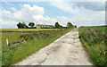
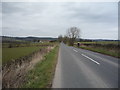
Footpath on farm track off North Lane, Cawthorne
Image: © Humphrey Bolton
Taken: 13 Jun 2020
0.20 miles
3
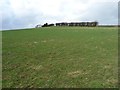
Vestigial hedgerow near Upper Elmhirst
To the west of Haigh Lane.
Image: © Christine Johnstone
Taken: 30 Jan 2013
0.21 miles
4
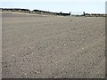
Footpath to Wood Royd, across Gadding Moor
Not much sign of recent use.
Image: © Christine Johnstone
Taken: 28 Sep 2011
0.21 miles
6
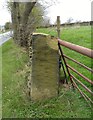
Gatepost with benchmark
Broken gatepost with benchmark, North Lane, Cawthorne.
Image: © Alan Clark
Taken: 6 Apr 2012
0.24 miles