IMAGES TAKEN NEAR TO
Capitol Close, BARNSLEY, S75 3UB
Introduction
This page details the photographs taken nearby to Capitol Close, S75 3UB by members of the Geograph project.
The Geograph project started in 2005 with the aim of publishing, organising and preserving representative images for every square kilometre of Great Britain, Ireland and the Isle of Man.

There are currently over 7.5m images from over14,400 individuals and you can help contribute to the project by visiting https://www.geograph.org.uk
Image Map
Images are licensed for reuse under creativecommons.org/licenses/by-sa/2.0
Notes
- Clicking on the map will re-center to the selected point.
- The higher the marker number, the further away the image location is from the centre of the postcode.
Image Listing (12 Images Found)
Images are licensed for reuse under creativecommons.org/licenses/by-sa/2.0
Image
Details
Distance
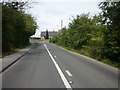
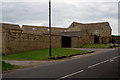
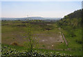
4
Higham Lane
Looking towards the bend at Lane Head Farm
Image: © Mark Anderson
Taken: 20 May 2011
0.07 miles
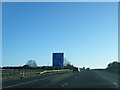
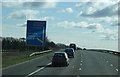
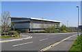
6
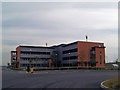
New office development Barnsley
Just off junction 37 M1 motorway is this new development, accompanying the Dodworth by pass.
Image: © Steve Fareham
Taken: 30 Sep 2007
0.14 miles