IMAGES TAKEN NEAR TO
Champany Fields, BARNSLEY, S75 3TS
Introduction
This page details the photographs taken nearby to Champany Fields, S75 3TS by members of the Geograph project.
The Geograph project started in 2005 with the aim of publishing, organising and preserving representative images for every square kilometre of Great Britain, Ireland and the Isle of Man.

There are currently over 7.5m images from over14,400 individuals and you can help contribute to the project by visiting https://www.geograph.org.uk
Image Map
Images are licensed for reuse under creativecommons.org/licenses/by-sa/2.0
Notes
- Clicking on the map will re-center to the selected point.
- The higher the marker number, the further away the image location is from the centre of the postcode.
Image Listing (56 Images Found)
Images are licensed for reuse under creativecommons.org/licenses/by-sa/2.0
Image
Details
Distance
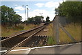
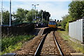
4
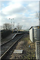
Dodworth Station
A station on the mostly single-track Penistone line between Huddersfield and Barnsley.
Image: © Chris Yeates
Taken: 28 Jan 2006
0.10 miles
5
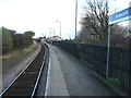
Dodworth railway station, Yorkshire
Opened in 1854 by the South Yorkshire Railway on the line from Barnsley to Penistone, this station closed in 1959. It was rebuilt and reopened in 1989 on the same site. View north east towards Summer Lane and Barnsley.
Image: © Nigel Thompson
Taken: 1 Nov 2009
0.11 miles