IMAGES TAKEN NEAR TO
Edale Rise, BARNSLEY, S75 3SF
Introduction
This page details the photographs taken nearby to Edale Rise, S75 3SF by members of the Geograph project.
The Geograph project started in 2005 with the aim of publishing, organising and preserving representative images for every square kilometre of Great Britain, Ireland and the Isle of Man.

There are currently over 7.5m images from over14,400 individuals and you can help contribute to the project by visiting https://www.geograph.org.uk
Image Map
Images are licensed for reuse under creativecommons.org/licenses/by-sa/2.0
Notes
- Clicking on the map will re-center to the selected point.
- The higher the marker number, the further away the image location is from the centre of the postcode.
Image Listing (61 Images Found)
Images are licensed for reuse under creativecommons.org/licenses/by-sa/2.0
Image
Details
Distance
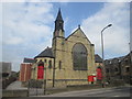
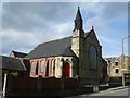
3
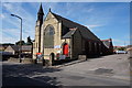
Dodworth Methodist Church
On Dodworth Green Road, Dodworth.
Image: © Ian S
Taken: 24 Aug 2016
0.06 miles
4
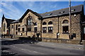
Former Wesleyan School
On Dodworth Green Road. Dated 1873.
Image: © Ian S
Taken: 24 Aug 2016
0.06 miles
6
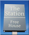
The Station
Public House on Station Road, Dodworth. http://www.geograph.org.uk/photo/5089834
Image: © Ian S
Taken: 24 Aug 2016
0.06 miles
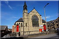
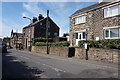
7
Dodworth Methodist Church
On Dodworth Green Road.
Image: © JThomas
Taken: 3 Oct 2014
0.06 miles
8

The Station
Public House on Station Road, Dodworth. http://www.geograph.org.uk/photo/5089837
Image: © Ian S
Taken: 24 Aug 2016
0.07 miles