IMAGES TAKEN NEAR TO
Saville Road, BARNSLEY, S75 3PX
Introduction
This page details the photographs taken nearby to Saville Road, S75 3PX by members of the Geograph project.
The Geograph project started in 2005 with the aim of publishing, organising and preserving representative images for every square kilometre of Great Britain, Ireland and the Isle of Man.

There are currently over 7.5m images from over14,400 individuals and you can help contribute to the project by visiting https://www.geograph.org.uk
Image Map
Images are licensed for reuse under creativecommons.org/licenses/by-sa/2.0
Notes
- Clicking on the map will re-center to the selected point.
- The higher the marker number, the further away the image location is from the centre of the postcode.
Image Listing (9 Images Found)
Images are licensed for reuse under creativecommons.org/licenses/by-sa/2.0
Image
Details
Distance
1
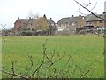
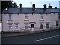
Houses on Rockingham Road, Gilroyd
The southern edge of the village, seen from the former railway line.
Image: © Christine Johnstone
Taken: 19 Mar 2016
0.13 miles
2
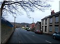
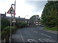
Keresforth Road at Dodworth Bottom
Image: © Jonathan Clitheroe
Taken: 8 Feb 2017
0.14 miles
3
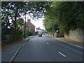
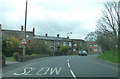
Keresforth Road (B6099), Dodworth Bottom
Heading west.
Image: © JThomas
Taken: 3 Oct 2014
0.15 miles
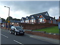
5
Children's nursery formerly Miners Inn
Image: © Alex McGregor
Taken: 14 Oct 2014
0.21 miles
6
Keresforth Road (B6099)
Approaching sharp bend, Dodworth Bottom.
Image: © JThomas
Taken: 3 Oct 2014
0.21 miles
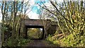
9
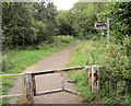
Sign to Wentworth Castle.
On the Trans Pennine Trail.
Image: © Steve Fareham
Taken: 2 Sep 2007
0.25 miles