IMAGES TAKEN NEAR TO
Mitchelson Avenue, BARNSLEY, S75 3JN
Introduction
This page details the photographs taken nearby to Mitchelson Avenue, S75 3JN by members of the Geograph project.
The Geograph project started in 2005 with the aim of publishing, organising and preserving representative images for every square kilometre of Great Britain, Ireland and the Isle of Man.

There are currently over 7.5m images from over14,400 individuals and you can help contribute to the project by visiting https://www.geograph.org.uk
Image Map
Images are licensed for reuse under creativecommons.org/licenses/by-sa/2.0
Notes
- Clicking on the map will re-center to the selected point.
- The higher the marker number, the further away the image location is from the centre of the postcode.
Image Listing (42 Images Found)
Images are licensed for reuse under creativecommons.org/licenses/by-sa/2.0
Image
Details
Distance
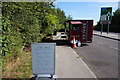
1
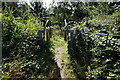
Penistone Rail Trail towards Dodworth Train Station
Image: © Ian S
Taken: 24 Aug 2016
0.12 miles
2
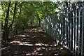
Penistone Rail Trail towards Dodworth Train Station
Image: © Ian S
Taken: 24 Aug 2016
0.12 miles
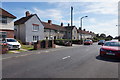
5

Holiday Inn hotel Barnsley
Formerly the Brooklands hotel re branded September 2009 as a Holiday Inn.
Image: © Steve Fareham
Taken: 28 Jan 2010
0.15 miles
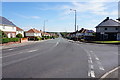
9

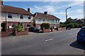
The Station
Public House on Station Road, Dodworth. http://www.geograph.org.uk/photo/5089837
Image: © Ian S
Taken: 24 Aug 2016
0.17 miles
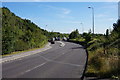
10
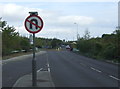
Approaching a roundabout on the A628
Whinby Road heading east.
Image: © JThomas
Taken: 3 Oct 2014
0.17 miles