IMAGES TAKEN NEAR TO
Chantry Orchards, BARNSLEY, S75 3HX
Introduction
This page details the photographs taken nearby to Chantry Orchards, S75 3HX by members of the Geograph project.
The Geograph project started in 2005 with the aim of publishing, organising and preserving representative images for every square kilometre of Great Britain, Ireland and the Isle of Man.

There are currently over 7.5m images from over14,400 individuals and you can help contribute to the project by visiting https://www.geograph.org.uk
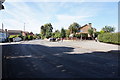
Image Map
Images are licensed for reuse under creativecommons.org/licenses/by-sa/2.0
Notes
- Clicking on the map will re-center to the selected point.
- The higher the marker number, the further away the image location is from the centre of the postcode.
Image Listing (48 Images Found)
Images are licensed for reuse under creativecommons.org/licenses/by-sa/2.0
Image
Details
Distance
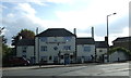
3
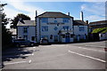
Travellers Inn
Public House on Dodworth Green Road, Dodworth. http://www.geograph.org.uk/photo/5089954
Image: © Ian S
Taken: 24 Aug 2016
0.06 miles
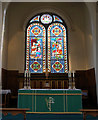
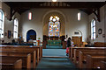
6
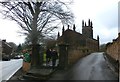
Church of St John the Baptist in Dodworth
Attractive church, constructed in the perpendicular style but with strikingly sturdy cone-shaped pinnacles. It's also an example of a Commissioners' church (also known as Waterloo or Million Act Churches) which were built using parliamentary funds following the Church Building Act of 1818. The building is located at the very southern edge of this grid square with Dodworth Green Road on the left of picture positioned to the south in SK3104.
Image: © Jonathan Clitheroe
Taken: 10 Feb 2017
0.07 miles
7

Travellers Inn
Public House on Dodworth Green Road, Dodworth. http://www.geograph.org.uk/photo/5089952
Image: © Ian S
Taken: 24 Aug 2016
0.07 miles
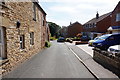
9
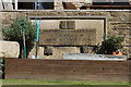
Dodworth Town School Inscription Stone
In the garden of a house built on the site of the former school. The stone is dated 1853. http://www.geograph.org.uk/photo/5090016
Image: © Ian S
Taken: 24 Aug 2016
0.07 miles
10
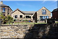
Dwelling on the site of the former Dodworth Town School
In the garden of a house built on the site of the former school. The stone is dated 1853. http://www.geograph.org.uk/photo/5090011
Image: © Ian S
Taken: 24 Aug 2016
0.07 miles