IMAGES TAKEN NEAR TO
Castle View, BARNSLEY, S75 3HB
Introduction
This page details the photographs taken nearby to Castle View, S75 3HB by members of the Geograph project.
The Geograph project started in 2005 with the aim of publishing, organising and preserving representative images for every square kilometre of Great Britain, Ireland and the Isle of Man.

There are currently over 7.5m images from over14,400 individuals and you can help contribute to the project by visiting https://www.geograph.org.uk
Image Map
Images are licensed for reuse under creativecommons.org/licenses/by-sa/2.0
Notes
- Clicking on the map will re-center to the selected point.
- The higher the marker number, the further away the image location is from the centre of the postcode.
Image Listing (10 Images Found)
Images are licensed for reuse under creativecommons.org/licenses/by-sa/2.0
Image
Details
Distance
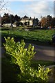
1
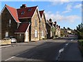
Village Street Hood Green
To the north of the houses on the left the land drops away steeply to the valley below. This landscape feature has influenced the ribbon development along the main street of Hood Green.
Image: © Wendy North
Taken: 23 Nov 2006
0.06 miles
3
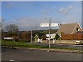
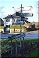
Signpost Hood Green
A choice of routes - the Baggerwood Hill route leading directly to Silkstone Common.
Image: © Wendy North
Taken: 23 Nov 2006
0.12 miles
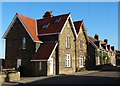
4
Cottage - Hood Green
This traditional stone cottage (probably 18th century) lies on the western edge of Hood Green.
Image: © Wendy North
Taken: 23 Nov 2006
0.12 miles
6
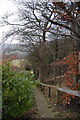
From Hood Green to the North
A series of concrete steps carry the footpath down from Hood Green out into open country.
Image: © Chris Yeates
Taken: 4 Feb 2006
0.18 miles
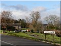
7

Rural bus leaving Hood Green
Bus services are still an essential service for many people in the community. For some people these provide the only means of travelling to doctors, hospitals and shops.
Image: © Wendy North
Taken: 23 Nov 2006
0.19 miles
8
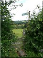
Footpath to Lower Falthwaite
The footpath passes diagonally and downhill across a grass field before entering a copse of trees.
Image: © Wendy North
Taken: 20 Jul 2008
0.20 miles
10

View towards Stainborough Folds
View through winter trees.
Image: © Wendy North
Taken: 18 Dec 2011
0.23 miles