IMAGES TAKEN NEAR TO
Stainborough Lane, BARNSLEY, S75 3HA
Introduction
This page details the photographs taken nearby to Stainborough Lane, S75 3HA by members of the Geograph project.
The Geograph project started in 2005 with the aim of publishing, organising and preserving representative images for every square kilometre of Great Britain, Ireland and the Isle of Man.

There are currently over 7.5m images from over14,400 individuals and you can help contribute to the project by visiting https://www.geograph.org.uk
Image Map
Images are licensed for reuse under creativecommons.org/licenses/by-sa/2.0
Notes
- Clicking on the map will re-center to the selected point.
- The higher the marker number, the further away the image location is from the centre of the postcode.
Image Listing (8 Images Found)
Images are licensed for reuse under creativecommons.org/licenses/by-sa/2.0
Image
Details
Distance
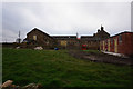
4
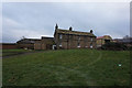
Wood Nook
Splendid mullioned windows are a feature of this simple, but beautifully-proportioned farmhouse - thanks heavens they have been retained.
Image: © Chris Yeates
Taken: 4 Feb 2006
0.17 miles
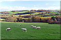
6
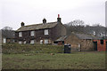
Wood Nook
A solid and undoubtedly old farmstead pictured here amid the last gasps of a fine September day.
Image: © Jonathan Clitheroe
Taken: 18 Sep 2013
0.18 miles