IMAGES TAKEN NEAR TO
Parwich Walk, BARNSLEY, S75 3FB
Introduction
This page details the photographs taken nearby to Parwich Walk, S75 3FB by members of the Geograph project.
The Geograph project started in 2005 with the aim of publishing, organising and preserving representative images for every square kilometre of Great Britain, Ireland and the Isle of Man.

There are currently over 7.5m images from over14,400 individuals and you can help contribute to the project by visiting https://www.geograph.org.uk
Image Map
Images are licensed for reuse under creativecommons.org/licenses/by-sa/2.0
Notes
- Clicking on the map will re-center to the selected point.
- The higher the marker number, the further away the image location is from the centre of the postcode.
Image Listing (60 Images Found)
Images are licensed for reuse under creativecommons.org/licenses/by-sa/2.0
Image
Details
Distance
2
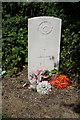
20193 Corporal W Folks
Grave in Didworth Cemetery.
Image: © Ian S
Taken: 24 Aug 2016
0.08 miles
5
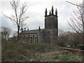
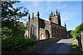
St John the Baptist church.
Dodworth near Barnsley.
Image: © steven ruffles
Taken: 6 Apr 2019
0.08 miles
8
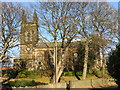
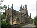
St John the Baptist Church at Dodworth
Viewed from the road to the south.
Image: © Peter Wood
Taken: 4 Dec 2013
0.10 miles
10
Dwelling on the site of the former Dodworth Town School
In the garden of a house built on the site of the former school. The stone is dated 1853. http://www.geograph.org.uk/photo/5090011
Image: © Ian S
Taken: 24 Aug 2016
0.10 miles