IMAGES TAKEN NEAR TO
Lidgett Lane, BARNSLEY, S75 3BS
Introduction
This page details the photographs taken nearby to Lidgett Lane, S75 3BS by members of the Geograph project.
The Geograph project started in 2005 with the aim of publishing, organising and preserving representative images for every square kilometre of Great Britain, Ireland and the Isle of Man.

There are currently over 7.5m images from over14,400 individuals and you can help contribute to the project by visiting https://www.geograph.org.uk
Image Map
Images are licensed for reuse under creativecommons.org/licenses/by-sa/2.0
Notes
- Clicking on the map will re-center to the selected point.
- The higher the marker number, the further away the image location is from the centre of the postcode.
Image Listing (7 Images Found)
Images are licensed for reuse under creativecommons.org/licenses/by-sa/2.0
Image
Details
Distance
4
The old line of Pilley Lane
Before the M1 arrived, this was the line of the road from Pilley to Birdwell. Nowadays, this is a dead end and the new road goes to the left of this line to a bridge over the motorway
Image: © John Slater
Taken: 29 Feb 2012
0.21 miles
5
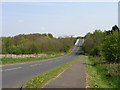
Pilley Lane
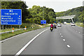
This quiet road cut through lovely countryside. The white edges to the lane at the top of the picture are the bridge parapet as it passes over the M1.
Image: © Carol Rose
Taken: 27 Apr 2007
0.23 miles
6
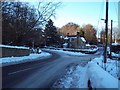
Road Junction in Lower Pilley
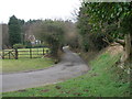
A wintery scene on New Road with Lidgett Lane forking off to the right. The dwelling at the road junction is Lidgett House.
Image: © Jonathan Clitheroe
Taken: 5 Dec 2010
0.24 miles
7
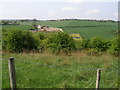
Rough farmland on the side of the M1
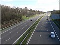
The M1 is low down and cannot be seen as it cuts through the countryside. On the hillside opposite there are some works which appear to be connected with sewage treatment.
Image: © Carol Rose
Taken: 27 Apr 2007
0.25 miles