IMAGES TAKEN NEAR TO
Pilley Hills, BARNSLEY, S75 3AU
Introduction
This page details the photographs taken nearby to Pilley Hills, S75 3AU by members of the Geograph project.
The Geograph project started in 2005 with the aim of publishing, organising and preserving representative images for every square kilometre of Great Britain, Ireland and the Isle of Man.

There are currently over 7.5m images from over14,400 individuals and you can help contribute to the project by visiting https://www.geograph.org.uk
Image Map
Images are licensed for reuse under creativecommons.org/licenses/by-sa/2.0
Notes
- Clicking on the map will re-center to the selected point.
- The higher the marker number, the further away the image location is from the centre of the postcode.
Image Listing (6 Images Found)
Images are licensed for reuse under creativecommons.org/licenses/by-sa/2.0
Image
Details
Distance
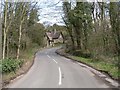
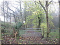
1
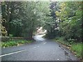
Pilley Bridge on Hermit Hill Lane
A chateau-style dwelling (under renovation at the time of posting) can be glimpsed beyond the bridge.
Image: © Jonathan Clitheroe
Taken: 12 Oct 2013
0.10 miles
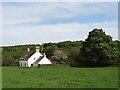
2
House from Pilley Bridge
Known to us as 'The Gingerbread House' because of its shape, decorative features and location in a heavily wooded area. Usually the house seems to be lost in the gloom of the wood though on this occasion the sun had performed a transformation.
Image: © Wendy North
Taken: 16 Apr 2006
0.10 miles
3
Trail into woods from Pilley Hills
Evening light warms the trail into the woods from the steep Pilley Hill. Bluebells are in abundance.
Image: © Steve Fareham
Taken: 6 May 2008
0.11 miles
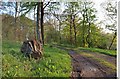
4
Track into the woods near Pilley Bridge
Some thoughtful person has provided a seat!
Image: © John Slater
Taken: 15 Nov 2014
0.12 miles
5
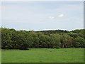
Woods at Green Springs
Near Hermit Hill.
Image: © Neil Theasby
Taken: 11 May 2015
0.21 miles