IMAGES TAKEN NEAR TO
Pilley Green, BARNSLEY, S75 3AB
Introduction
This page details the photographs taken nearby to Pilley Green, S75 3AB by members of the Geograph project.
The Geograph project started in 2005 with the aim of publishing, organising and preserving representative images for every square kilometre of Great Britain, Ireland and the Isle of Man.

There are currently over 7.5m images from over14,400 individuals and you can help contribute to the project by visiting https://www.geograph.org.uk
Image Map
Images are licensed for reuse under creativecommons.org/licenses/by-sa/2.0
Notes
- Clicking on the map will re-center to the selected point.
- The higher the marker number, the further away the image location is from the centre of the postcode.
Image Listing (8 Images Found)
Images are licensed for reuse under creativecommons.org/licenses/by-sa/2.0
Image
Details
Distance
1
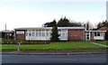
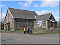
Pilley Green
The name of both the road and the area, which is a suburb of Barnsley close to the M1 motorway.
Image: © Graham Hogg
Taken: 18 Jan 2012
0.10 miles
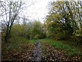
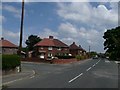
2
The footpath from Pilley towards Wortley
Image: © John Slater
Taken: 29 Feb 2012
0.20 miles
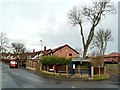
4
Pilley Methodist Chapel
Chapel goers gather outside the Methodist Chapel on Easter Sunday. They are standing on the corner of Chapel Lane and Pilley Lane.
Image: © Wendy North
Taken: 16 Apr 2006
0.21 miles
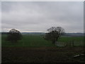
5
Entering Pilley Village
The Timberland Trail continues. We enter Pilley on Carr Lane walking towards Pilley Green.
Image: © Wendy North
Taken: 26 Jul 2008
0.23 miles
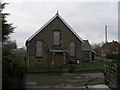
7
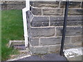
Cut benchmark on Pilley Methodist Church
For a view of the church see Image
Image: © John Slater
Taken: 29 Feb 2012
0.24 miles