IMAGES TAKEN NEAR TO
Crowden Walk, BARNSLEY, S75 2LU
Introduction
This page details the photographs taken nearby to Crowden Walk, S75 2LU by members of the Geograph project.
The Geograph project started in 2005 with the aim of publishing, organising and preserving representative images for every square kilometre of Great Britain, Ireland and the Isle of Man.

There are currently over 7.5m images from over14,400 individuals and you can help contribute to the project by visiting https://www.geograph.org.uk
Image Map
Images are licensed for reuse under creativecommons.org/licenses/by-sa/2.0
Notes
- Clicking on the map will re-center to the selected point.
- The higher the marker number, the further away the image location is from the centre of the postcode.
Image Listing (8 Images Found)
Images are licensed for reuse under creativecommons.org/licenses/by-sa/2.0
Image
Details
Distance
3
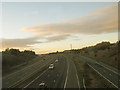
M1 north of junction 37
Viewed from a train on the line between Barnsley and Penistone.
Image: © Stephen Craven
Taken: 5 Nov 2016
0.18 miles
4
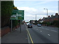
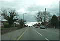
Dodworth Road (A628)
Heading north east into Barnsley.
Image: © JThomas
Taken: 3 Oct 2014
0.18 miles
6
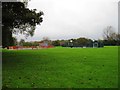
Play area and games court Penny Pie Park
Image: © Alex McGregor
Taken: 14 Oct 2014
0.20 miles