IMAGES TAKEN NEAR TO
Colster Close, BARNSLEY, S75 2LR
Introduction
This page details the photographs taken nearby to Colster Close, S75 2LR by members of the Geograph project.
The Geograph project started in 2005 with the aim of publishing, organising and preserving representative images for every square kilometre of Great Britain, Ireland and the Isle of Man.

There are currently over 7.5m images from over14,400 individuals and you can help contribute to the project by visiting https://www.geograph.org.uk
Image Map
Images are licensed for reuse under creativecommons.org/licenses/by-sa/2.0
Notes
- Clicking on the map will re-center to the selected point.
- The higher the marker number, the further away the image location is from the centre of the postcode.
Image Listing (19 Images Found)
Images are licensed for reuse under creativecommons.org/licenses/by-sa/2.0
Image
Details
Distance
2
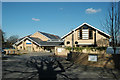
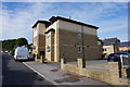
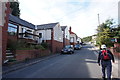
Barnsley Hospice
A modern purpose-built building situated across the road from St Thomas's Church in Gawber. The shadow in the foreground is not the photographer.
Image: © Chris Yeates
Taken: 3 Mar 2006
0.13 miles