IMAGES TAKEN NEAR TO
Weaver Close, BARNSLEY, S75 1PY
Introduction
This page details the photographs taken nearby to Weaver Close, S75 1PY by members of the Geograph project.
The Geograph project started in 2005 with the aim of publishing, organising and preserving representative images for every square kilometre of Great Britain, Ireland and the Isle of Man.

There are currently over 7.5m images from over14,400 individuals and you can help contribute to the project by visiting https://www.geograph.org.uk
Image Map
Images are licensed for reuse under creativecommons.org/licenses/by-sa/2.0
Notes
- Clicking on the map will re-center to the selected point.
- The higher the marker number, the further away the image location is from the centre of the postcode.
Image Listing (32 Images Found)
Images are licensed for reuse under creativecommons.org/licenses/by-sa/2.0
Image
Details
Distance
2
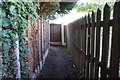
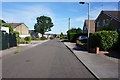
Penistone Rail Trail towards Lawrence Close, Higham
Image: © Ian S
Taken: 24 Aug 2016
0.08 miles
3

Penistone Rail Trail towards Lawrence Close, Higham
Image: © Ian S
Taken: 24 Aug 2016
0.08 miles

7

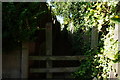
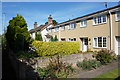
Penistone Rail Trail towards Higham Common Lane
Image: © Ian S
Taken: 24 Aug 2016
0.11 miles
10
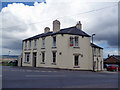
Higham, Yorkshire: The 'Engineers Arms'
In the 1980s, this area together with other coalmining areas, took a severe battering with the loss of many jobs, and this of course had a knock-on effect on the whole of the local economy. Many pubs closed, but the 'Engineers' was one of the survivors, becoming, I think, the only pub. left in Higham
Image: © Dr Neil Clifton
Taken: 27 Apr 2013
0.12 miles