IMAGES TAKEN NEAR TO
Pog Well Lane, BARNSLEY, S75 1PJ
Introduction
This page details the photographs taken nearby to Pog Well Lane, S75 1PJ by members of the Geograph project.
The Geograph project started in 2005 with the aim of publishing, organising and preserving representative images for every square kilometre of Great Britain, Ireland and the Isle of Man.

There are currently over 7.5m images from over14,400 individuals and you can help contribute to the project by visiting https://www.geograph.org.uk
Image Map
Images are licensed for reuse under creativecommons.org/licenses/by-sa/2.0
Notes
- Clicking on the map will re-center to the selected point.
- The higher the marker number, the further away the image location is from the centre of the postcode.
Image Listing (16 Images Found)
Images are licensed for reuse under creativecommons.org/licenses/by-sa/2.0
Image
Details
Distance
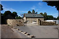
4
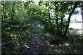
Pogwell Lane
The lane passes under the nearby M1 motorway and continues to Dodworth.
Image: © Steve Fareham
Taken: 31 Dec 2008
0.07 miles
5
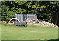
Pit Mining Wheels and Wagon
At Higham Bottoms. Taken from the public footpath.
Image: © Ian S
Taken: 24 Aug 2016
0.07 miles
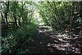
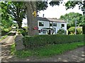
7
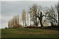
From Lombardy to Barnsley
A line of lombardy poplars edge a field near Hugset Wood (though an 'ent' appears to be also demanding attention!)
Image: © Chris Yeates
Taken: 3 Mar 2006
0.10 miles
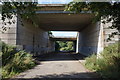
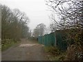
8
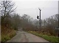
Power cables cross Pogwell Lane
Just beyond the tunnel under the M1 motorway.
Image: © Steve Fareham
Taken: 31 Dec 2008
0.11 miles