IMAGES TAKEN NEAR TO
Willow Bank, BARNSLEY, S75 1EF
Introduction
This page details the photographs taken nearby to Willow Bank, S75 1EF by members of the Geograph project.
The Geograph project started in 2005 with the aim of publishing, organising and preserving representative images for every square kilometre of Great Britain, Ireland and the Isle of Man.

There are currently over 7.5m images from over14,400 individuals and you can help contribute to the project by visiting https://www.geograph.org.uk
Image Map
Images are licensed for reuse under creativecommons.org/licenses/by-sa/2.0
Notes
- Clicking on the map will re-center to the selected point.
- The higher the marker number, the further away the image location is from the centre of the postcode.
Image Listing (32 Images Found)
Images are licensed for reuse under creativecommons.org/licenses/by-sa/2.0
Image
Details
Distance
2
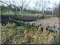
Stone wall on the south bank of the Barnsley Canal
Presumably a wharf wall, as the towpath is on the opposite [north] side. If so it must have been early, because it is not present on maps from the 1840s onwards. The Barnsley Canal was built to carry coal out of the Barnsley coalfields. It opened in early 1802 and formally closed in 1953.
Image: © Christine Johnstone
Taken: 31 Dec 2017
0.15 miles
3
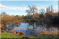
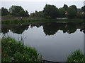
Tinker's Pond
Urban legend says that the two ponds are bottomless. Not sure about that, however we saw a Roach being caught. Walking further down you come to a bridge over the old Barnsley canal, Martin Speck photo shows this Image
Image: © Martin Lee
Taken: 28 Jan 2012
0.15 miles
4
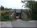
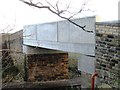
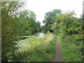
Barrier on the Barnsley Canal near Smithies
This section of the canal ran from Barnsley to Barnby Basin; it was constructed in early 1802 and closed in 1953. This barrier appears to have been constructed more recently but, other than as an unofficial footbridge, its purpose is not clear.
Image: © Graham Hogg
Taken: 11 Jan 2012
0.15 miles
9
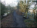
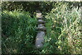
Stile on the Barnsley Canal towpath
Leading to an informal path alongside the River Dearne [not a public footpath].
Image: © Christine Johnstone
Taken: 31 Dec 2017
0.17 miles