IMAGES TAKEN NEAR TO
Mason Way, BARNSLEY, S74 9TF
Introduction
This page details the photographs taken nearby to Mason Way, S74 9TF by members of the Geograph project.
The Geograph project started in 2005 with the aim of publishing, organising and preserving representative images for every square kilometre of Great Britain, Ireland and the Isle of Man.

There are currently over 7.5m images from over14,400 individuals and you can help contribute to the project by visiting https://www.geograph.org.uk
Image Map
Images are licensed for reuse under creativecommons.org/licenses/by-sa/2.0
Notes
- Clicking on the map will re-center to the selected point.
- The higher the marker number, the further away the image location is from the centre of the postcode.
Image Listing (16 Images Found)
Images are licensed for reuse under creativecommons.org/licenses/by-sa/2.0
Image
Details
Distance
2
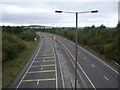
Dearne Valley Parkway (A6195)
Looking west from the bridge on Barnsley Road.
Image: © JThomas
Taken: 27 Sep 2014
0.09 miles
3
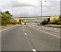
Bridge to Blacker Hill over Dearne Valley Parkway.
Image: © Steve Fareham
Taken: 18 Sep 2007
0.12 miles
4
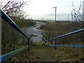
Steps on public footpath at Platts Common
Little used, like several other footpaths in this area. The road is the recently constructed A6195 M1-A1(M) link road through the Dearne Valley.
Image: © Graham Hogg
Taken: 18 Jan 2012
0.12 miles
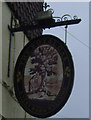
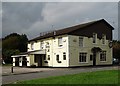
7
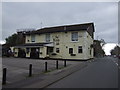
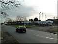
The Royal Oak, Platts Common
On Barnsley Road.
Image: © JThomas
Taken: 27 Sep 2014
0.15 miles
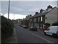
9
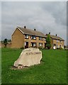
In Platts Common
According to a local resident I met - a former coal miner - this village stone cost Barnsley Council £10,000. The grassy area was once the corner location of some humble miners' cottages
Image: © Neil Theasby
Taken: 21 Sep 2014
0.17 miles
10

Hoyland Nether
The Wombwell Road (B6096) into the mining village of Hoyland Nether, near Platt's Common. Silkstone Colliery is behind.
Image: © David Dixon
Taken: Unknown
0.19 miles