IMAGES TAKEN NEAR TO
Wood View, BARNSLEY, S74 8JB
Introduction
This page details the photographs taken nearby to Wood View, S74 8JB by members of the Geograph project.
The Geograph project started in 2005 with the aim of publishing, organising and preserving representative images for every square kilometre of Great Britain, Ireland and the Isle of Man.

There are currently over 7.5m images from over14,400 individuals and you can help contribute to the project by visiting https://www.geograph.org.uk
Image Map (Loading...)


Getting Data...Please wait
Leaflet Map data © OpenStreetMap
Images are licensed for reuse under creativecommons.org/licenses/by-sa/2.0
Notes
- Clicking on the map will re-center to the selected point.
- The higher the marker number, the further away the image location is from the centre of the postcode.
Image Listing (98 Images Found)
Images are licensed for reuse under creativecommons.org/licenses/by-sa/2.0
Image
Details
Distance
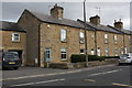
1
Fitzwilliam Street, Elsecar
Looking up towards Hill Street. The cottages to the right are part of the Elsecar Conservation Area.
Image: © Alan Murray-Rust
Taken: 13 Sep 2009
0.09 miles
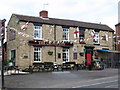
2
Elsecar - The Fitzwilliam Arms
On Hill Street.
Image: © Dave Bevis
Taken: 12 Jun 2010
0.09 miles
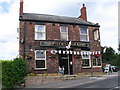
4
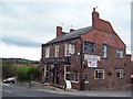
The Fitzwilliam Arms in Elsecar
Public House located on Hill Street close to Elsecar railway station.
Image: © Jonathan Clitheroe
Taken: 5 Oct 2011
0.11 miles
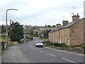
5
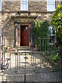
Lovely old door portico on Hill Street, opposite Elsecar Station
Image: © Carol Rose
Taken: 27 Apr 2007
0.12 miles
6
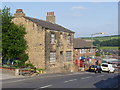
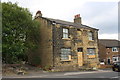
31 Hill Street, Elsecar
The name Parkins Yard on the side of the house refers to an area which has now become its back garden. The house appears at some stage to have been a Beer House (a pub with a licence to sell beer only, and not wines or spirits).
Image: © Alan Murray-Rust
Taken: 8 Jul 2013
0.13 miles
7
Benchmark on #31 Hill Street
Ordnance Survey cut mark benchmark levelled at 81.245m above Newlyn Datum
Image: © Roger Templeman
Taken: 14 Aug 2018
0.13 miles
8
#31 Hill Street
Described by the Ordnance Survey as a public house, but probably only licensed for beer .. more than it does now! There is an OS benchmark Image on the near corner, left hand face, of the building, under the Parkins Yard name sign
Image: © Roger Templeman
Taken: 14 Aug 2018
0.13 miles
9
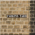
Parkins Yard
Street names consisting of a series of individual ceramic tiles with the letters on are a local feature. In this case, Parkins Yard as such has disappeared, but the name remains in situ.
Image: © Alan Murray-Rust
Taken: 8 Jul 2013
0.13 miles