IMAGES TAKEN NEAR TO
Allott Crescent, BARNSLEY, S74 0LD
Introduction
This page details the photographs taken nearby to Allott Crescent, S74 0LD by members of the Geograph project.
The Geograph project started in 2005 with the aim of publishing, organising and preserving representative images for every square kilometre of Great Britain, Ireland and the Isle of Man.

There are currently over 7.5m images from over14,400 individuals and you can help contribute to the project by visiting https://www.geograph.org.uk
Image Map
Images are licensed for reuse under creativecommons.org/licenses/by-sa/2.0
Notes
- Clicking on the map will re-center to the selected point.
- The higher the marker number, the further away the image location is from the centre of the postcode.
Image Listing (18 Images Found)
Images are licensed for reuse under creativecommons.org/licenses/by-sa/2.0
Image
Details
Distance
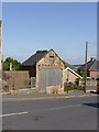
1
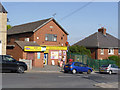
Jump Post Office and Wentworth Road Stores
The Post Office used to be on the opposite side of the road.
Image: © Alan Murray-Rust
Taken: 8 Jul 2013
0.14 miles
2
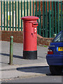
Post Office/18 Wentworth Road Jump postbox ref S74 11
A typical E II R Royal Mail pillar box installed at a Post Office after the split of Royal Mail.
Image: © Alan Murray-Rust
Taken: 8 Jul 2013
0.14 miles
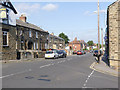
3
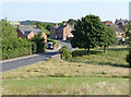
Wentworth Road in Jump Valley
The immediate foreground would at one time have been filled with the embankment carrying the Midland railway connection to the incline up to Hoyland Silkstone Colliery.
Image: © Alan Murray-Rust
Taken: 8 Jul 2013
0.16 miles
4
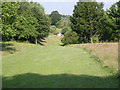
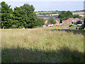
Site of railway sidings
The mown area of grass indicates roughly the line of the connection between the Midland railway line and the incline. The connection was on an embankment which has been completely removed and re-landscaped.
Image: © Alan Murray-Rust
Taken: 8 Jul 2013
0.16 miles
5
Line of former Hoyland Silkstone Colliery tramroad incline
Looking down the line of the original tramroad to where it crossed Wentworth Road.
Image: © Alan Murray-Rust
Taken: 8 Jul 2013
0.18 miles
6
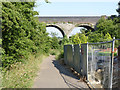
Footpath along the old incline
Looking from Wentworth Road through the Midland Railway viaduct.
Image: © Alan Murray-Rust
Taken: 8 Jul 2013
0.19 miles
7
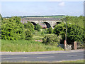
Jump Valley viaduct
Carrying the Midland Railway line from Sheffield to Barnsley. This was built as late as 1895 as an extension of the branch from Sheffield to Chapeltown, primarily to tap the coal traffic in the Barnsley area.
Image: © Alan Murray-Rust
Taken: 8 Jul 2013
0.19 miles
8
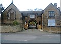
Chapel and Lodge at the Entrance to Jump Cemetery
Situated on Cemetery Road this burial ground is shared with the neighbouring village of Hemingfield. Several fallen war heroes are interred here.
Image: © Jonathan Clitheroe
Taken: 17 Feb 2017
0.19 miles
9
Cemetery Road, Jump
This is effectively the main street of Jump.
Image: © Alan Murray-Rust
Taken: 8 Jul 2013
0.20 miles
10
Former shop on Wentworth Road
See http://www.geograph.org.uk/photo/3549933 for more information.
Image: © Alan Murray-Rust
Taken: 8 Jul 2013
0.20 miles