IMAGES TAKEN NEAR TO
Belvedere Drive, BARNSLEY, S73 9RL
Introduction
This page details the photographs taken nearby to Belvedere Drive, S73 9RL by members of the Geograph project.
The Geograph project started in 2005 with the aim of publishing, organising and preserving representative images for every square kilometre of Great Britain, Ireland and the Isle of Man.

There are currently over 7.5m images from over14,400 individuals and you can help contribute to the project by visiting https://www.geograph.org.uk
Image Map
Images are licensed for reuse under creativecommons.org/licenses/by-sa/2.0
Notes
- Clicking on the map will re-center to the selected point.
- The higher the marker number, the further away the image location is from the centre of the postcode.
Image Listing (24 Images Found)
Images are licensed for reuse under creativecommons.org/licenses/by-sa/2.0
Image
Details
Distance
1

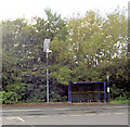
Autumn leaf at a bus shelter, Darfield
One of the glass panels was shattered - either deliberately or accidentally - I could not say.
Image: © Neil Theasby
Taken: 13 Nov 2022
0.04 miles
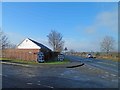
2
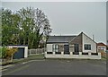
Bungalow on Belvedere Drive
On the west side of Darfield
Image: © Neil Theasby
Taken: 13 Nov 2022
0.05 miles
4
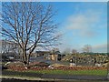
Yew Tree garden centre Darfield
In the 1950's a transport café then a petrol station (60's and 70's) and for many years now a garden centre.
Image: © Steve Fareham
Taken: 13 Jan 2013
0.08 miles
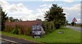
5
Old milestone near Darfield
Though half-hidden in a hedgerow, it's nice to see that this old milestone has benefited from maintenance
Image: © Neil Theasby
Taken: 13 Nov 2022
0.09 miles
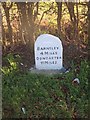
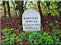
7
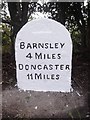
Old Milestone by the former A635, Saltersbrook Road, Darfield Parish
Carved stone post by the former A635, in parish of DARFIELD (BARNSLEY District), West end of Darfield near Garden Centre, on what is now a short link road, 150m East of junction with Saltersbrook Road, on the verge, under hedge, on East side of road. Road re-aligned mid 20th century leaving milestone in its original location. Erected by the Doncaster & Salter's Brook turnpike trust in the 18th/19th century.
Inscription reads:-
BARNSLEY
4 MILES
DONCASTER
11 MILES
Grade II listed. List Entry Number: 1287062
https://historicengland.org.uk/listing/the-list/list-entry/1287062
Milestone Society National ID: YS_DNBN11.
Image: © C Minto
Taken: 1 Jan 1992
0.10 miles
8
Mid August, it must be global warming!
Image: © Steve Fareham
Taken: 13 Aug 2007
0.10 miles
9
Yew Tree garden centre alongside the A635
Image: © Steve Fareham
Taken: 13 Jan 2013
0.10 miles