IMAGES TAKEN NEAR TO
Doncaster Road, BARNSLEY, S73 9JF
Introduction
This page details the photographs taken nearby to Doncaster Road, S73 9JF by members of the Geograph project.
The Geograph project started in 2005 with the aim of publishing, organising and preserving representative images for every square kilometre of Great Britain, Ireland and the Isle of Man.

There are currently over 7.5m images from over14,400 individuals and you can help contribute to the project by visiting https://www.geograph.org.uk
Image Map
Images are licensed for reuse under creativecommons.org/licenses/by-sa/2.0
Notes
- Clicking on the map will re-center to the selected point.
- The higher the marker number, the further away the image location is from the centre of the postcode.
Image Listing (19 Images Found)
Images are licensed for reuse under creativecommons.org/licenses/by-sa/2.0
Image
Details
Distance
1
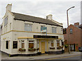
Not quite the Goldmine expected.
was known as the Station inn, or 'Debney's'.
Image: © Steve Fareham
Taken: 11 Aug 2007
0.03 miles
2
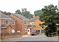
Furniture still outside weeks after the floods.
This whole area was devastated by the river Dreane flooding. Darfield Church in background.
Image: © Steve Fareham
Taken: 11 Aug 2007
0.10 miles
3
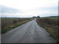
Entering Darfield from the east on the A635.
Image: © Steve Fareham
Taken: 11 Aug 2007
0.13 miles
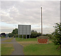
4
Houghton Main colliery 1979
In the centre is the distinctive spoil heap 'muck stack'.
Image: © Steve Fareham
Taken: Unknown
0.14 miles
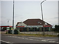
7
Dearne Valley Motors.
Once known as Camps garage.
Image: © Steve Fareham
Taken: 11 Aug 2007
0.15 miles
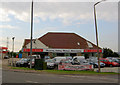
8
Dearne Valley Motor Company on Doncaster Road
Image: © Ian S
Taken: 29 Jul 2011
0.16 miles
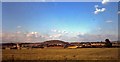
9
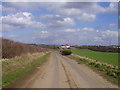
View from Fitzwilliam Road to Middlecliffe
Image: © Neil Theasby
Taken: 21 May 2015
0.17 miles
10
Site of former Darfield station
View SW, across the site of the station and the disused ex-Midland four-track main line from Sheffield and Rotherham (to left) to Normanton and Leeds (to right). The station was closed 17/6/63, while from 1/1/68 all passenger trains were diverted off the route between Wath Road Junction and Goose Hill Junction (Normanton) owing to colliery subsidences, although freight trains were still worked over it for several more years.
Image: © Ben Brooksbank
Taken: 21 Jun 1992
0.17 miles