IMAGES TAKEN NEAR TO
Cliff Road, BARNSLEY, S73 9HR
Introduction
This page details the photographs taken nearby to Cliff Road, S73 9HR by members of the Geograph project.
The Geograph project started in 2005 with the aim of publishing, organising and preserving representative images for every square kilometre of Great Britain, Ireland and the Isle of Man.

There are currently over 7.5m images from over14,400 individuals and you can help contribute to the project by visiting https://www.geograph.org.uk
Image Map
Images are licensed for reuse under creativecommons.org/licenses/by-sa/2.0
Notes
- Clicking on the map will re-center to the selected point.
- The higher the marker number, the further away the image location is from the centre of the postcode.
Image Listing (36 Images Found)
Images are licensed for reuse under creativecommons.org/licenses/by-sa/2.0
Image
Details
Distance
1
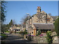
Cottages in Cliff Road, Darfield
On the lane that linked the first railway station to Darfield.
Image: © Jonathan Thacker
Taken: 8 Apr 2011
0.01 miles
2
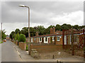
Cliff road old folks bungalows.
Now empty after the floods which reached almost the level of the eaves.
Image: © Steve Fareham
Taken: 17 Aug 2007
0.04 miles
3
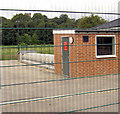
Darfield Army Cadets rifle range.
Recently flooded on Cliff Road.
Image: © Steve Fareham
Taken: 17 Aug 2007
0.08 miles
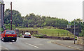
4

Cliffe Road Darfield flooded for second time in 10 days
Image: © Joan Fareham
Taken: 26 Jun 2007
0.11 miles
5
Site of former Darfield station
View SW, across the site of the station and the disused ex-Midland four-track main line from Sheffield and Rotherham (to left) to Normanton and Leeds (to right). The station was closed 17/6/63, while from 1/1/68 all passenger trains were diverted off the route between Wath Road Junction and Goose Hill Junction (Normanton) owing to colliery subsidences, although freight trains were still worked over it for several more years.
Image: © Ben Brooksbank
Taken: 21 Jun 1992
0.17 miles
6
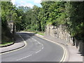
Missing Bridge
The railway and bridge have long gone but the walls that once supported the bridge will be around for a few more years.
Image: © Michael Patterson
Taken: 7 Sep 2006
0.17 miles
7
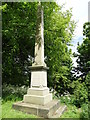
"Prepare to Meet Thy God"
The Lundhill Explosion Memorial in Darfield churchyard. It happened at Lundhill Colliery, Wombwell on February 19th, 1852. One hundred and eighty nine men and boys were killed. At that very time eleven year old Elizabeth Ashton was making "herb beer" at her home nearby. Interviewed by "The Times" in 1928, she remembered going to the pithead with other local women to try to identify the bodies. She said, “They were as black as coal, and it was impossible to tell one from another.”
Image: © Neil Theasby
Taken: 21 May 2015
0.17 miles
8

Steps to the Church
The footpath is closed at the moment with a gate just ahead.
Image: © Steve Fareham
Taken: 23 Aug 2008
0.18 miles
9
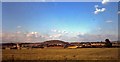
Houghton Main colliery 1979
In the centre is the distinctive spoil heap 'muck stack'.
Image: © Steve Fareham
Taken: Unknown
0.18 miles
10
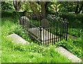
The Grave of Ebenezer Elliott, Darfield
Ebenezer Elliott is often known as "The Corn Law Rhymer". He is buried in Darfield churchyard with his wife, Frances Gartside, He lived in South Yorkshire from 1781 to 1849 and as a poet and vocal supporter of the downtrodden was revered by thousands of working people across the land. A statue of him once occupied a prominent place in the centre of Sheffield but urban developments later saw it moved to Weston Park near the University of Sheffield.
When wilt thou save the people?
Oh, God of Mercy! when?
The people, Lord, the people !
Not thrones and crowns, but men!
God! save the people! thine they are,
Thy children, as thy angels fair:
Save them from bondage, and despair !
God, save the people !
http://en.wikipedia.org/wiki/Ebenezer_Elliott
Image: © Neil Theasby
Taken: 21 May 2015
0.18 miles