IMAGES TAKEN NEAR TO
Aldham House Lane, BARNSLEY, S73 8RZ
Introduction
This page details the photographs taken nearby to Aldham House Lane, S73 8RZ by members of the Geograph project.
The Geograph project started in 2005 with the aim of publishing, organising and preserving representative images for every square kilometre of Great Britain, Ireland and the Isle of Man.

There are currently over 7.5m images from over14,400 individuals and you can help contribute to the project by visiting https://www.geograph.org.uk
Image Map
Images are licensed for reuse under creativecommons.org/licenses/by-sa/2.0
Notes
- Clicking on the map will re-center to the selected point.
- The higher the marker number, the further away the image location is from the centre of the postcode.
Image Listing (33 Images Found)
Images are licensed for reuse under creativecommons.org/licenses/by-sa/2.0
Image
Details
Distance

3
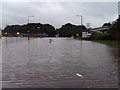
Wombwell Lane flooded
A view down Wombwell Lane towards Aldham Bridge. The now demolished Perfecta Beds site is to the left of the picture.
Image: © Jeff Pearson
Taken: 25 Jun 2007
0.12 miles
4
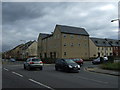
Flats on Simons Way, Wombwell
High above the Trans Pennine Trail, a former railway line.
Image: © Christine Johnstone
Taken: 3 Dec 2016
0.13 miles
5
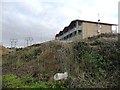
Rear of Aldham cottages.
Foreground Billington Structures dispatch area.
Image: © Steve Fareham
Taken: 26 Jul 2007
0.13 miles
6
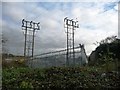
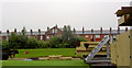
Electricity site off Aldham House Lane
Fenced to deter intruders.
Image: © Christine Johnstone
Taken: 3 Dec 2016
0.14 miles
7
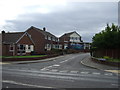
Barnwell Crescent, Wombwell
Off Barnsley Road.
Image: © JThomas
Taken: 27 Sep 2014
0.14 miles
8
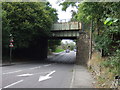
Disused railway bridge over Barnsley Road
Now used by National Cycle Route 62.
Image: © JThomas
Taken: 27 Sep 2014
0.15 miles
9
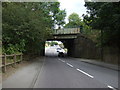
Disused railway bridge over Barnsley Road
Now used by National Cycle Route 62.
Image: © JThomas
Taken: 27 Sep 2014
0.15 miles
10

Trans Pennine Trail, below Simons Way, Wombwell
A former railway line turned orange by autumn leaves and bracken.
Image: © Christine Johnstone
Taken: 3 Dec 2016
0.15 miles