IMAGES TAKEN NEAR TO
Bierlow Close, BARNSLEY, S73 0TJ
Introduction
This page details the photographs taken nearby to Bierlow Close, S73 0TJ by members of the Geograph project.
The Geograph project started in 2005 with the aim of publishing, organising and preserving representative images for every square kilometre of Great Britain, Ireland and the Isle of Man.

There are currently over 7.5m images from over14,400 individuals and you can help contribute to the project by visiting https://www.geograph.org.uk
Image Map
Images are licensed for reuse under creativecommons.org/licenses/by-sa/2.0
Notes
- Clicking on the map will re-center to the selected point.
- The higher the marker number, the further away the image location is from the centre of the postcode.
Image Listing (31 Images Found)
Images are licensed for reuse under creativecommons.org/licenses/by-sa/2.0
Image
Details
Distance
1

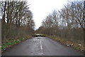
'Snowman Toy' Police Blockade Site, Knollbeck Lane, Bramton, near Barnsley
Immediately to the right of this picture, behind the trees and houses,
is the former Pit Lane to the infamous Cortonwood Colliery … see …
Image
Back in 1984, during the Miners' Strike, the police lined up across Knollbeck Lane, just to the right of the steps shown, and blocked off access to the Pit Lane.
A memorable picture of this area and a miner taunting the police with a snowman toy can be seen by following this http://en.wikipedia.org/wiki/UK_miners%27_strike_(1984%E2%80%931985) .
The Wikipedia picture also shows the Cortonwood Colliery entrance sign as described in the linked former Pit Lane picture.
The relevance of the snowman taunt … well, that's another story to investigate.
Image: © Terry Robinson
Taken: 16 Jan 2014
0.03 miles
2
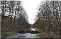
Pit Lane to the former Cortonwood Colliery, off Knollbeck Lane, Brampton Brierley, near Barnsley - 1
This Road - known as Pit Lane - originally led to Cortonwood Colliery …
I understand that the lane originally had gates, suitably endorsed with the name
'Cortonwood Colliery' but that these were ordered to be removed during the
infamous 1984 Miner's Strike so that they couldn't be preserved by the Miners
and used for propaganda purposes.
Immediately to the left of this picture was the site of a Police Blockade, infamously
remembered in a photograph showing a Miner taunting the Police with a Snownan Toy …
… see this picture and follow the link …
Image
The lane is now closed off to Road Traffic but is still open as a footpath and leads
to the Cortonwood Enterprise Zone and Retail Park … see …
Image
A World War 1 Memorial, listing the names of all the Cortonwood Colliery Miners who
enlisted for service, and (sadly) confirming those who died during service, was sited
and dedicated in 1919, outside the Colliery Offices part way along this Lane.
This was moved in 1985 - following the closure of the Colliery - and placed opposite
the Cortonwood Miner's Welfare Club. It was re-dedicated in 1986
See also …
Image
Image: © Terry Robinson
Taken: 7 Jan 2014
0.04 miles
3
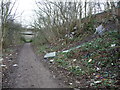
Pit Lane to the former Cortonwood Colliery, off Knollbeck Lane, Brampton Brierley, near Barnsley - 2
For full information about his historic Lane … see …
Image
The front of the houses on the left can be seen in …
Image
Image: © Terry Robinson
Taken: 7 Jan 2014
0.04 miles
4
Fly-tipped rubbish on Elsecar Greenway
Tipped over a wall at the top of the bank.
Image: © Christine Johnstone
Taken: 5 Feb 2017
0.05 miles
6
![B6089 [Brampton Road] crossing Knoll Beck](https://s3.geograph.org.uk/geophotos/05/27/50/5275031_66c7a0eb_120x120.jpg)
B6089 [Brampton Road] crossing Knoll Beck
The viaduct also crosses the Dearne Valley Parkway [A6195].
Image: © Christine Johnstone
Taken: 5 Feb 2017
0.07 miles
7
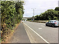
Bridge over the Dearne Valley Parkway near Wath Roundabout
The A6195 road is mainly newly constructed, being built to regenerate the former coal-mining areas of Barnsley in the late 1990s.
Image: © David Dixon
Taken: 17 Aug 2018
0.08 miles
8
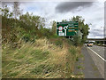
Dearne Valley Parkway (A6195)
The A6195 road is mainly newly constructed, being built to regenerate the former coal-mining areas of Barnsley in the late 1990s.
Image: © David Dixon
Taken: 17 Aug 2018
0.09 miles
9
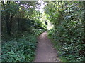
The Trans Pennine Trail
The Trail here is on a path beside the new A6195 road and adjacent to the Barnsley/Rotherham boundary.
Image: © Graham Hogg
Taken: 18 Nov 2011
0.09 miles
10
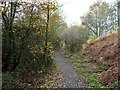
The Trans Pennine Trail
Disused railway trail heading south west.
Image: © JThomas
Taken: 27 Sep 2014
0.09 miles