IMAGES TAKEN NEAR TO
Knollbeck Avenue, BARNSLEY, S73 0TH
Introduction
This page details the photographs taken nearby to Knollbeck Avenue, S73 0TH by members of the Geograph project.
The Geograph project started in 2005 with the aim of publishing, organising and preserving representative images for every square kilometre of Great Britain, Ireland and the Isle of Man.

There are currently over 7.5m images from over14,400 individuals and you can help contribute to the project by visiting https://www.geograph.org.uk
Image Map
Images are licensed for reuse under creativecommons.org/licenses/by-sa/2.0
Notes
- Clicking on the map will re-center to the selected point.
- The higher the marker number, the further away the image location is from the centre of the postcode.
Image Listing (35 Images Found)
Images are licensed for reuse under creativecommons.org/licenses/by-sa/2.0
Image
Details
Distance
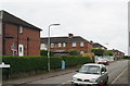
2
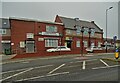
Cortonwood Comeback Community Centre, Chapel Lane, Brampton
This former Chapel - on the aptly named Chapel lane - has been refurbished into the Cortonwood Comeback Community Centre. This chapel was used during the 1984 Miners Strike as a refuge and rest centre for the striking miners and their families.
Image: © Terry Robinson
Taken: 25 May 2009
0.15 miles
3
Brampton Cortonwood Infant School, Chapel Lane, Brampton
Image: © Terry Robinson
Taken: 25 May 2009
0.15 miles
4

Footpath to Wynmoor Crescent, Brampton Bierlow
Next to the fire station is a handy short cut footpath to the houses at the rear.
Image: © Terry Robinson
Taken: 25 May 2009
0.15 miles
5
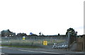
Former Fire Station Site, Knollbeck Lane, Brampton Bierlow, near Barnsley - 2
Compare this view with ... Image ... taken in 2009
The Fire Station was closed in June 2010 and the disused building suffered the ignominy of a fire in July 2011 which destroyed the empty premises. The site is due for re-development but at the date of this photograph there is no sign of any activity.
The footpath still remains ... as footpaths tend to do!
See also ...
Image
Image
Image: © Terry Robinson
Taken: 16 Sep 2012
0.16 miles
6
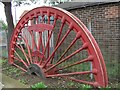
Pit Winding Wheel
This is a section of the winding wheel from Cortonwood Colliery, where the miners' strike started in 1984. The wheel is an addition to the nearby war memorial commemorating the lives lost in the two world wars.
Image: © Richard Whitham
Taken: 6 Oct 2006
0.17 miles
7

Former Fire Station Site, Knollbeck Lane, Brampton Bierlow, near Barnsley - 3
Image: © Terry Robinson
Taken: 16 Sep 2012
0.17 miles
9
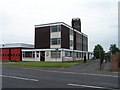
Fire Station, Knollbeck Lane, Brampton Bierlow, near Barnsley - 2
See also ...
Image
Update in September 2012 ... Compare this view with ...
Image
The Fire Station was closed in June 2010 and the disused building suffered the ignominy of a fire in July 2011 which destroyed the empty premises. The site is due for re-development but at the date of this photograph there is no sign of any activity.
See also ...
Image
Image: © Terry Robinson
Taken: 25 May 2009
0.18 miles
10
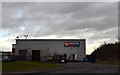
Windsor Food Service, Cortonwood Drive, Cortonwood Business Park, Brampton, near Barnsley
The Cortonwood Business Park, and the nearby Cortonwood Retail Park, were constructed
in the mid1990s on land which was formerly Cortonwood Colliery. The announcement
of the closure of this Colliery was the catalyst for the Miner's Strike in 1984.
The footpath to the right of this building leads to the former Pit Lane,
which was the official entrance to the Colliery … see …
Image
See also …
Image
Image
Image
Image
Image: © Terry Robinson
Taken: 7 Jan 2014
0.18 miles