IMAGES TAKEN NEAR TO
Tingle Close, BARNSLEY, S73 0NW
Introduction
This page details the photographs taken nearby to Tingle Close, S73 0NW by members of the Geograph project.
The Geograph project started in 2005 with the aim of publishing, organising and preserving representative images for every square kilometre of Great Britain, Ireland and the Isle of Man.

There are currently over 7.5m images from over14,400 individuals and you can help contribute to the project by visiting https://www.geograph.org.uk
Image Map
Images are licensed for reuse under creativecommons.org/licenses/by-sa/2.0
Notes
- Clicking on the map will re-center to the selected point.
- The higher the marker number, the further away the image location is from the centre of the postcode.
Image Listing (64 Images Found)
Images are licensed for reuse under creativecommons.org/licenses/by-sa/2.0
Image
Details
Distance
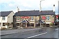
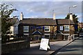
2
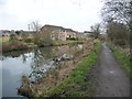
Elephant and Castle, Hemingfield
Former canalside pub which would also have served the local mining community.
Image: © Alan Murray-Rust
Taken: 8 Jul 2013
0.02 miles
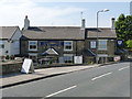
4
Canal and Public House in Hemingfield
Canalside pubs are at a premium in South Yorkshire and a scramble through thick vegetation was required to capture both features here. The pub is the Elephant and Castle and the canal is the Elsecar branch of the Dearne and Dove.
Image: © Jonathan Clitheroe
Taken: 7 Oct 2011
0.03 miles
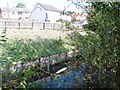
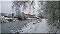
5
New houses west of Tingle Bridge
On the north bank of the Elsecar branch of the Dearne & Dove Canal, at the site of Tingle Bridge Lock. The canal was built to carry coal from local collieries. It had opened by 1798, at least 30 years before any railway competition. It closed to traffic [due to mining subsidence] in 1928. It was officially closed in 1961. The towpath is well used by walkers and cyclists and a local group is keen to restore the canal.
Image: © Christine Johnstone
Taken: 5 Feb 2017
0.04 miles
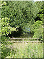
6
The site of Tingle Bridge Lock
Looking west from Tingle Bridge. The lock, and the pound below, have been cascaded. The canal was built to carry coal from local collieries. It had opened by 1798, at least 30 years before any railway competition. It closed to traffic [due to mining subsidence] in 1928. It was officially closed in 1961.
Image: © Christine Johnstone
Taken: 5 Feb 2017
0.05 miles
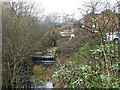
7
Dearne and Dove Canal
Looking east from Tingle Lane Bridge. The bridge itself has been filled in.
Image: © Alan Murray-Rust
Taken: 8 Jul 2013
0.06 miles
9
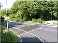
Hemingfield Level Crossing
Installed as part of the Elsecar Heritage Railway's project to extend their line to Cortonwood. As can be seen, the line itself has progressed no further at this stage.
Image: © Alan Murray-Rust
Taken: 8 Jul 2013
0.06 miles
10
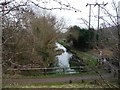
Elsecar Branch, east from Tingle Bridge
The canal was built to carry coal from local collieries. It had opened by 1798, at least 30 years before any railway competition. It closed to traffic [due to mining subsidence] in 1928. It was officially closed in 1961. The towpath is well used by walkers and cyclists and a local group is keen to restore the canal.
Image: © Christine Johnstone
Taken: 5 Feb 2017
0.07 miles