IMAGES TAKEN NEAR TO
Town Lands Close, BARNSLEY, S73 0BQ
Introduction
This page details the photographs taken nearby to Town Lands Close, S73 0BQ by members of the Geograph project.
The Geograph project started in 2005 with the aim of publishing, organising and preserving representative images for every square kilometre of Great Britain, Ireland and the Isle of Man.

There are currently over 7.5m images from over14,400 individuals and you can help contribute to the project by visiting https://www.geograph.org.uk
Image Map
Images are licensed for reuse under creativecommons.org/licenses/by-sa/2.0
Notes
- Clicking on the map will re-center to the selected point.
- The higher the marker number, the further away the image location is from the centre of the postcode.
Image Listing (19 Images Found)
Images are licensed for reuse under creativecommons.org/licenses/by-sa/2.0
Image
Details
Distance
2
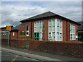
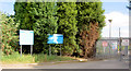
St Michael and All Angels Catholic Primary School
On Stonyford Road.
Image: © JThomas
Taken: 27 Sep 2014
0.09 miles
3
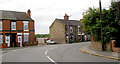
Scarborough corner Low Valley.
This area suffered badly in the recent floods.
Image: © Steve Fareham
Taken: 17 Aug 2007
0.12 miles
4
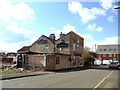
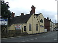
The Drop Public House, Darfield
Probably the last view of this public house before it is demolished.
Image: © Bill Henderson
Taken: 18 Mar 2012
0.17 miles
8
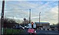
Low Valley roadworks
Junction of Pitt Street with George Street.
Image: © Steve Fareham
Taken: 19 Jan 2013
0.19 miles
9
The Wat Tyler Inn
Pub on Station Road (currently closed).
Image: © JThomas
Taken: 27 Sep 2014
0.19 miles
10
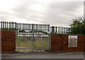
Gates to what was the football pitch, now new school.
Opposite the end of Pitt Street.
Image: © Steve Fareham
Taken: 15 Aug 2007
0.20 miles