IMAGES TAKEN NEAR TO
Marsh Street, BARNSLEY, S73 0AG
Introduction
This page details the photographs taken nearby to Marsh Street, S73 0AG by members of the Geograph project.
The Geograph project started in 2005 with the aim of publishing, organising and preserving representative images for every square kilometre of Great Britain, Ireland and the Isle of Man.

There are currently over 7.5m images from over14,400 individuals and you can help contribute to the project by visiting https://www.geograph.org.uk
Image Map
Images are licensed for reuse under creativecommons.org/licenses/by-sa/2.0
Notes
- Clicking on the map will re-center to the selected point.
- The higher the marker number, the further away the image location is from the centre of the postcode.
Image Listing (82 Images Found)
Images are licensed for reuse under creativecommons.org/licenses/by-sa/2.0
Image
Details
Distance
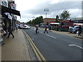
1
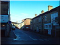
Smith Street, Wombwell
Off Station Road.
Image: © Richard Vince
Taken: 6 Jan 2024
0.04 miles
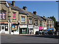
2
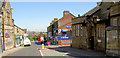
Wombwell library.
On the right the library on the left the new Temple Gym, which was the Salvation Army Citadel. The road has been one way for years making it difficult to get to the shops on Wombwell high street for people from Darfield.
Image: © Steve Fareham
Taken: 24 Aug 2007
0.05 miles
3
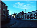
Station Road, Wombwell
Leading from a roundabout on the A633 (which bypasses the town) into the town centre.
Image: © Richard Vince
Taken: 6 Jan 2024
0.06 miles
4
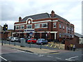
The Horseshoe, Wombwell
A Wetherspoon pub on High Street.
Image: © JThomas
Taken: 27 Sep 2014
0.06 miles
5

The rear of Wombwell Library
From the car park where the market used to be.
Image: © Steve Fareham
Taken: 21 Apr 2008
0.08 miles
7
Wombwell - shops on north-west side of Station Road
Image: © Dave Bevis
Taken: 31 May 2013
0.08 miles
8
North end of Mayflower Way, Wombwell
Approaching the roundabout where the A633 crosses Station Road.
Image: © Richard Vince
Taken: 6 Jan 2024
0.09 miles
9
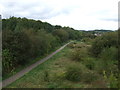
The Trans Pennine Trail, Wombwell
On a disused railway (L. & N. E. R.). Looking north west from Station Road.
Image: © JThomas
Taken: 27 Sep 2014
0.09 miles
10
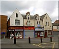
Snazzy's
Shops across the road from the Town Hall, the shop on the right of Snazzy's was a Bank.
Image: © Steve Fareham
Taken: 1 May 2008
0.09 miles