IMAGES TAKEN NEAR TO
Edge Hill Road, SHEFFIELD, S7 1SP
Introduction
This page details the photographs taken nearby to Edge Hill Road, S7 1SP by members of the Geograph project.
The Geograph project started in 2005 with the aim of publishing, organising and preserving representative images for every square kilometre of Great Britain, Ireland and the Isle of Man.

There are currently over 7.5m images from over14,400 individuals and you can help contribute to the project by visiting https://www.geograph.org.uk
Image Map
Images are licensed for reuse under creativecommons.org/licenses/by-sa/2.0
Notes
- Clicking on the map will re-center to the selected point.
- The higher the marker number, the further away the image location is from the centre of the postcode.
Image Listing (32 Images Found)
Images are licensed for reuse under creativecommons.org/licenses/by-sa/2.0
Image
Details
Distance
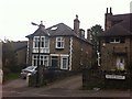
1
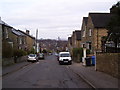
Nether Edge Road
This view is similar to the Frith Collection picture S108095. http://www.francisfrith.com/sheffield/photos/nether-edge-road-c1955_s108095/
Image: © Martin Speck
Taken: 16 Mar 2012
0.10 miles
2
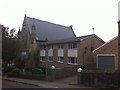
Union Road
1960s flats next to King's Centre Christian Church.
Image: © Burgess Von Thunen
Taken: 28 Sep 2013
0.11 miles
3
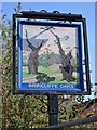
"Brincliffe Oaks" pub sign, Nether Edge, Sheffield
There was an ale house on this site in 1619 - Ye Olde Oak at Brincliffe. The pub was extended over the next four hundred years and had an annexe where private parties were often held as well as regular folk evenings. Sadly, it has remained empty since January 2007 and is now falling into grave disrepair. Another nail in the coffin of the traditional English pub.
Image: © Neil Theasby
Taken: 30 Mar 2012
0.11 miles
4
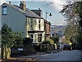
On Brincliffe Edge Road, Sheffield
At the junction with Nether Edge Road
Image: © Neil Theasby
Taken: 11 Nov 2016
0.12 miles
5
Union Road
Victorian detached house in Brincliffe.
Image: © Burgess Von Thunen
Taken: 28 Sep 2013
0.12 miles
6
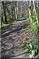
Brincliffe Edge - the path through the woods
Image: © Neil Theasby
Taken: 30 Mar 2012
0.14 miles
7
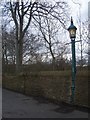
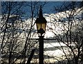
Brincliffe Edge Road Sewer gas lamp
One of Sheffield's last remaining Webb Patent Sewer Gas Destructor Lamps stands on Brincliffe Edge Road, opposite Union Road. Many cities had these lamps. Sheffield had 84 of them installed between 1915 and 1935. At least 22 are known to have survived to modern times with many of them being listed. This one is looked after by the Nether Edge Neighbourhood group. Also see Image
Image: © Martin Speck
Taken: 28 Mar 2009
0.14 miles
8
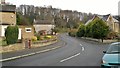
Archer Lane leading up to Brincliffe Edge
At one time this was a popular rat run route for commuters, but traffic calming measures have put paid to most of that.
Image: © Chris Morgan
Taken: 24 Nov 2012
0.15 miles
9

Old gas lamp on Brincliffe Edge Road (II)
This is one of several Webb Patent Sewer Gas Destructor Lamps that were dotted around the hills of Sheffield burning off methane produced in the city's sewers. It is situated at the junction of Brincliffe Edge Road and Union Road. Sadly an urban graffiti tagger appears to have scrawled his moniker on the glass but the lamp is still burning as the mid-December afternoon begins to give way to nightfall. As you can see the lamppost is embedded in the stone wall.
Image: © Neil Theasby
Taken: 19 Dec 2017
0.16 miles
10
Old gas lamp on Brincliffe Edge Road (I)
This is one of several Webb Patent Sewer Gas Destructor Lamps that were dotted around the hills of Sheffield burning off methane produced in the city's sewers. It is situated at the junction of Brincliffe Edge Road and Union Road. Sadly an urban graffiti tagger appears to have scrawled his moniker on the glass but the lamp is still burning as the mid-December afternoon begins to give way to nightfall.
Image: © Neil Theasby
Taken: 19 Dec 2017
0.16 miles