IMAGES TAKEN NEAR TO
Edgebrook Road, SHEFFIELD, S7 1SG
Introduction
This page details the photographs taken nearby to Edgebrook Road, S7 1SG by members of the Geograph project.
The Geograph project started in 2005 with the aim of publishing, organising and preserving representative images for every square kilometre of Great Britain, Ireland and the Isle of Man.

There are currently over 7.5m images from over14,400 individuals and you can help contribute to the project by visiting https://www.geograph.org.uk
Image Map (Loading...)


Getting Data...Please wait
Leaflet Map data © OpenStreetMap
Images are licensed for reuse under creativecommons.org/licenses/by-sa/2.0
Notes
- Clicking on the map will re-center to the selected point.
- The higher the marker number, the further away the image location is from the centre of the postcode.
Image Listing (33 Images Found)
Images are licensed for reuse under creativecommons.org/licenses/by-sa/2.0
Image
Details
Distance
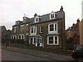
1
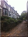
Barkers Road
Bay-fronted Victorian terraces in Nether Edge.
Image: © Burgess Von Thunen
Taken: 28 Sep 2013
0.03 miles
2
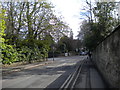
Union Road, Nether Edge (1)
Looking south towards the junction with Barker's Road, Edgebrook Road and Lyndhurst Road.
Image: © Richard Vince
Taken: 27 Apr 2013
0.06 miles
3
Union Road, Nether Edge (2)
Looking north, with Chestnut Court on the right. In the distance on the left can be seen a bus, laying over at the terminus of First Sheffield route 22 to Woodhouse via Sheffield city centre.
Image: © Richard Vince
Taken: 27 Apr 2013
0.06 miles
4
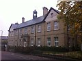
Ecclesall Bierlow Union Offices
Originally the offices of the workhouse across the road, this building has been converted into apartments.
Image: © Burgess Von Thunen
Taken: 28 Sep 2013
0.06 miles
5

Raven Road
Victorian terraces in Nether Edge.
Image: © Burgess Von Thunen
Taken: 28 Sep 2013
0.08 miles
6
Barkers Road
Victorian houses in Nether Edge.
Image: © Burgess Von Thunen
Taken: 28 Sep 2013
0.08 miles
7
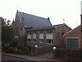
Union Road
1960s flats next to King's Centre Christian Church.
Image: © Burgess Von Thunen
Taken: 28 Sep 2013
0.11 miles
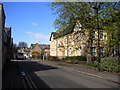
8

Union Road, Nether Edge (3)
The northern extremity of Union Road (before it becomes Cherry Tree Road), complete with a pub called The Union.
Image: © Richard Vince
Taken: 27 Apr 2013
0.12 miles
9

Osborne Road, Nether Edge
Looking west from its junction with Union Road.
Image: © Richard Vince
Taken: 27 Apr 2013
0.12 miles
10
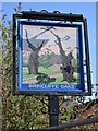
"Brincliffe Oaks" pub sign, Nether Edge, Sheffield
There was an ale house on this site in 1619 - Ye Olde Oak at Brincliffe. The pub was extended over the next four hundred years and had an annexe where private parties were often held as well as regular folk evenings. Sadly, it has remained empty since January 2007 and is now falling into grave disrepair. Another nail in the coffin of the traditional English pub.
Image: © Neil Theasby
Taken: 30 Mar 2012
0.13 miles