IMAGES TAKEN NEAR TO
Wostenholm Road, SHEFFIELD, S7 1LE
Introduction
This page details the photographs taken nearby to Wostenholm Road, S7 1LE by members of the Geograph project.
The Geograph project started in 2005 with the aim of publishing, organising and preserving representative images for every square kilometre of Great Britain, Ireland and the Isle of Man.

There are currently over 7.5m images from over14,400 individuals and you can help contribute to the project by visiting https://www.geograph.org.uk
Image Map
Images are licensed for reuse under creativecommons.org/licenses/by-sa/2.0
Notes
- Clicking on the map will re-center to the selected point.
- The higher the marker number, the further away the image location is from the centre of the postcode.
Image Listing (41 Images Found)
Images are licensed for reuse under creativecommons.org/licenses/by-sa/2.0
Image
Details
Distance
1
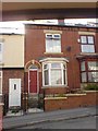
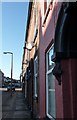
Typical housing of Sharrow.
This is Vincent Road.
Image: © Michael Hill-King
Taken: 23 Jul 2006
0.12 miles
2
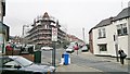
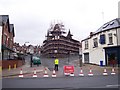
Old church gone to the scaffold
It had long since ceased to be a church when it caught fire in 2008, already surrounded by scaffolding. It seems nobody wants, or can afford, to demolish it, or renovate it.
Image: © Chris Morgan
Taken: 24 Nov 2012
0.16 miles
3
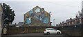
Street art, South View Road, Sheffield
Image: © Mike Pennington
Taken: 21 Oct 2023
0.16 miles
4
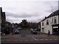
South View Road in 2013
South View Road after the demolition of a fire damaged former church.
Image: © Martin Speck
Taken: 30 Jun 2013
0.17 miles
5

Methodist New Connexion 1889
A former church on Sharrow Lane, Sheffield, now up for sale
Image: © Peter Barr
Taken: 30 Jan 2010
0.17 miles
6
Terraced houses with satellite dishes
Sharrow Lane, Sheffield
Image: © Peter Barr
Taken: 30 Jan 2010
0.17 miles
7
South View Road in 2008
South View Road is closed over fears that the fire damaged former church, being refurbished might collapse. Also see Image
Image: © Martin Speck
Taken: 18 Apr 2008
0.18 miles
8

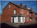
Premier corner shop
The corner of Sharrow Lane and Wostenholm Road. The visible part of an old painted sign gives the business name as Gowers. I don't know what they would have sold.
It appears to be a popular spot for feral pigeons,
Image: © David Lally
Taken: 26 Oct 2013
0.18 miles
9
Corner of Sharrow Lane and Langdon Street
The corner premises was occupied by a legal firm at the time of posting although previously it served as offices for the National Schizophrenia Fellowship. I was based here as a mental health worker between 2000 and 2004 looking after 20 self-contained flats across the city. It was a challenging job.
Image: © Jonathan Clitheroe
Taken: 8 Feb 2011
0.19 miles
10
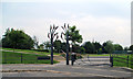
Mount Pleasant Park, Sheffield
created in 1983 from an area of housing clearance, funded by an urban development programme.
Image: © David Rogers
Taken: 12 Aug 2012
0.19 miles