IMAGES TAKEN NEAR TO
Lang Avenue, BARNSLEY, S71 5LT
Introduction
This page details the photographs taken nearby to Lang Avenue, S71 5LT by members of the Geograph project.
The Geograph project started in 2005 with the aim of publishing, organising and preserving representative images for every square kilometre of Great Britain, Ireland and the Isle of Man.

There are currently over 7.5m images from over14,400 individuals and you can help contribute to the project by visiting https://www.geograph.org.uk
Image Map
Images are licensed for reuse under creativecommons.org/licenses/by-sa/2.0
Notes
- Clicking on the map will re-center to the selected point.
- The higher the marker number, the further away the image location is from the centre of the postcode.
Image Listing (20 Images Found)
Images are licensed for reuse under creativecommons.org/licenses/by-sa/2.0
Image
Details
Distance
1
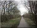
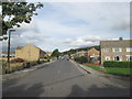
The Trans-Pennine Trail at Lundwood
Follows the route of the former Hull and Barnsley Railway.
Image: © Jonathan Thacker
Taken: 19 Mar 2018
0.03 miles

4
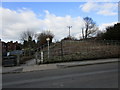
Access to the Trans-Pennine Trail
The former railway overbridge has been demolished.
Image: © Jonathan Thacker
Taken: 19 Mar 2018
0.13 miles
5
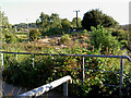
Zig zag access onto Trans Pennine Trail.
Image: © Steve Fareham
Taken: 7 Sep 2007
0.13 miles
7
The Lundwood Social Club
A Sam Smith's club in Lundwood.
Image: © Ian S
Taken: 18 Aug 2012
0.17 miles
8
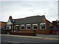
The Lundwood Social Club
A Sam Smith's club in Lundwood.
Image: © Ian S
Taken: 18 Aug 2012
0.17 miles
9
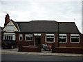
The Lundwood Social Club
A Sam Smith's club in Lundwood.
Image: © Ian S
Taken: 18 Aug 2012
0.17 miles
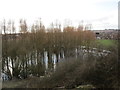
10
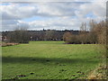
View towards Monk Bretton
Taken from the former railway embankment which now carries the Trans Pennine Trail. Monk Bretton Priory is just out of the picture to the left but the parish church is prominent on the hill.
Image: © Jonathan Thacker
Taken: 19 Mar 2018
0.17 miles