IMAGES TAKEN NEAR TO
Chapel Court, BARNSLEY, S71 5FA
Introduction
This page details the photographs taken nearby to Chapel Court, S71 5FA by members of the Geograph project.
The Geograph project started in 2005 with the aim of publishing, organising and preserving representative images for every square kilometre of Great Britain, Ireland and the Isle of Man.

There are currently over 7.5m images from over14,400 individuals and you can help contribute to the project by visiting https://www.geograph.org.uk
Image Map
Images are licensed for reuse under creativecommons.org/licenses/by-sa/2.0
Notes
- Clicking on the map will re-center to the selected point.
- The higher the marker number, the further away the image location is from the centre of the postcode.
Image Listing (13 Images Found)
Images are licensed for reuse under creativecommons.org/licenses/by-sa/2.0
Image
Details
Distance
1
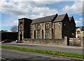
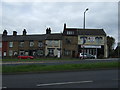
Antiques Emporium on Doncaster Road, Ardsley
As the architecture suggests it was once a chapel serving the local community.
Image: © Neil Theasby
Taken: 26 Apr 2015
0.03 miles
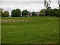
3
Scar Lane Ardsley.
Just above the park at Ardsley is one of the village's oldest lanes.
Image: © Steve Fareham
Taken: 22 Jul 2007
0.11 miles
4
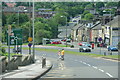
Approaching Stairfoot Roundabout
The A635 descends into a small valley off the Dearne Valley. This is effectively the beginning of the Barnsley conurbation.
Image: © Bill Boaden
Taken: 26 May 2014
0.15 miles
6
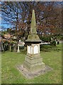
Oaks Colliery Disaster Memorial
In Ardsley Christ Church graveyard. Though largely forgotten in national consciousness the fatal explosion at the Oaks Colliery near Barnsley was for fifty years the worst coal mine disaster in British history. It happened on 12th December 1866 and claimed the lives of 361 men and boys. Of course the effects upon local communities was horrendous. For more information see:-
http://www.healeyhero.co.uk/rescue/pits/Oak.htm
Image: © Neil Theasby
Taken: 26 Apr 2015
0.20 miles
7
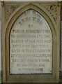
Inscription on the Oaks Colliery Disaster Memorial
In Ardsley Christ Church graveyard. Though largely forgotten in national consciousness the fatal explosion at the Oaks Colliery near Barnsley was for fifty years the worst coal mine disaster in British history. As the inscription indicates, it happened on 12th December 1866 and claimed the lives of 361 men and boys. Over twenty rescuers were killed on December 13th. Of course the effects upon local communities was horrendous. For more information see:-
http://www.healeyhero.co.uk/rescue/pits/Oak.htm
Image: © Neil Theasby
Taken: 26 Apr 2015
0.20 miles
8
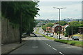
Doncaster Road in Ardsley
This is the A635 between Doncaster and Barnsley, now descending towards Barnsley.
Image: © Bill Boaden
Taken: 26 May 2014
0.22 miles
9
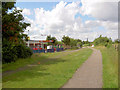
McDonald's on Trans Pennine trail Stairfoot.
Is this the only cycle through McDonald's on the trail?
Image: © Steve Fareham
Taken: 22 Jul 2007
0.23 miles
10
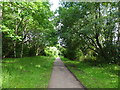
Ardsley (Stairfoot 1st) railway station (site), Yorkshire
Opened in 1851 As "Ardsley" by the South Yorkshire Railway, later part of the Manchester Sheffield & Lincolnshire Railway, on the line from Doncaster to Barnsley. The station was renamed "Stairfoot" in 1870 but then closed a little over a year later when it was replaced by another, immediately behind the camera position.
View south east along the track-bed towards Wombwell Central and Doncaster. No trace of the station now remains and it is a public footpath.
Image: © Nigel Thompson
Taken: 11 Jul 2020
0.23 miles