IMAGES TAKEN NEAR TO
Roehampton Rise, BARNSLEY, S71 5BN
Introduction
This page details the photographs taken nearby to Roehampton Rise, S71 5BN by members of the Geograph project.
The Geograph project started in 2005 with the aim of publishing, organising and preserving representative images for every square kilometre of Great Britain, Ireland and the Isle of Man.

There are currently over 7.5m images from over14,400 individuals and you can help contribute to the project by visiting https://www.geograph.org.uk
Image Map
Images are licensed for reuse under creativecommons.org/licenses/by-sa/2.0
Notes
- Clicking on the map will re-center to the selected point.
- The higher the marker number, the further away the image location is from the centre of the postcode.
Image Listing (14 Images Found)
Images are licensed for reuse under creativecommons.org/licenses/by-sa/2.0
Image
Details
Distance
1
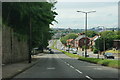
Doncaster Road in Ardsley
This is the A635 between Doncaster and Barnsley, now descending towards Barnsley.
Image: © Bill Boaden
Taken: 26 May 2014
0.09 miles
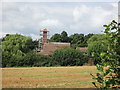
2
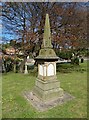
Oaks Colliery Disaster Memorial
In Ardsley Christ Church graveyard. Though largely forgotten in national consciousness the fatal explosion at the Oaks Colliery near Barnsley was for fifty years the worst coal mine disaster in British history. It happened on 12th December 1866 and claimed the lives of 361 men and boys. Of course the effects upon local communities was horrendous. For more information see:-
http://www.healeyhero.co.uk/rescue/pits/Oak.htm
Image: © Neil Theasby
Taken: 26 Apr 2015
0.10 miles
3
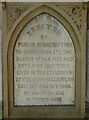
Inscription on the Oaks Colliery Disaster Memorial
In Ardsley Christ Church graveyard. Though largely forgotten in national consciousness the fatal explosion at the Oaks Colliery near Barnsley was for fifty years the worst coal mine disaster in British history. As the inscription indicates, it happened on 12th December 1866 and claimed the lives of 361 men and boys. Over twenty rescuers were killed on December 13th. Of course the effects upon local communities was horrendous. For more information see:-
http://www.healeyhero.co.uk/rescue/pits/Oak.htm
Image: © Neil Theasby
Taken: 26 Apr 2015
0.10 miles
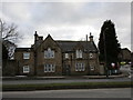
4
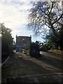
The end for Ardsley House Hotel
Soon to be new houses on this site. Ardsley House Hotel was for a long time the premier hotel in Barnsley. It was also a National Coal Board HQ and before that a private manor hall.
Image: © Steve Fareham
Taken: 13 Jan 2017
0.11 miles
5
Gothic in Ardsley
Most of Ardsley is pure twentieth century suburbia but some traces of the old village still remain.
Image: © Jonathan Thacker
Taken: 19 Mar 2018
0.13 miles
6
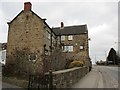
Remains of old Ardsley
Ardsely has become a largely twentieth century suburb but there are some remains of the old village. This house has had its southernmost wing partially demolished to make way for the dual carriageway to the right.
Image: © Jonathan Thacker
Taken: 19 Mar 2018
0.15 miles
7
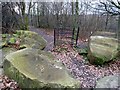
Redundant kissing gate
At this junction of the Trans Pennine Trail with a local public footpath the kissing gate has been made redundant by the siting of large rocks to discourage motorised traffic.
Image: © Graham Hogg
Taken: 11 Jan 2012
0.16 miles
8
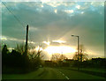
Ardsley sunburst
Looking west towards Barnsley on the A635 near the entrance to the crematorium, the white building off centre right is Top Fold.
Image: © Steve Fareham
Taken: 1 Apr 2008
0.19 miles
9

Flowering cherry trees in the grounds of Barnsley Crematorium
An avenue leading towards Ardsley House, a hotel and former NCB HQ. prior to that the home to the Micklethwaite family.
Image: © Steve Fareham
Taken: 28 Apr 2012
0.19 miles
10
Work in progress at Barnsley Crematorium
Image: © John Slater
Taken: 21 Aug 2016
0.21 miles