IMAGES TAKEN NEAR TO
Ashford Court, Haigh Moor Way, BARNSLEY, S71 4FF
Introduction
This page details the photographs taken nearby to Ashford Court, Haigh Moor Way, S71 4FF by members of the Geograph project.
The Geograph project started in 2005 with the aim of publishing, organising and preserving representative images for every square kilometre of Great Britain, Ireland and the Isle of Man.

There are currently over 7.5m images from over14,400 individuals and you can help contribute to the project by visiting https://www.geograph.org.uk
Image Map
Images are licensed for reuse under creativecommons.org/licenses/by-sa/2.0
Notes
- Clicking on the map will re-center to the selected point.
- The higher the marker number, the further away the image location is from the centre of the postcode.
Image Listing (27 Images Found)
Images are licensed for reuse under creativecommons.org/licenses/by-sa/2.0
Image
Details
Distance
1
Notton & Royston railway station (site), Yorkshire
Opened in 1882 by the Barnsley Coal Railway, soon to be part of the Manchester Sheffield & Lincolnshire Railway, on the short line from Nostell to Stairfoot, near Barnsley. The station closed to passengers in 1930.
Former entrance road (right) and bridge abutments (left).
Image: © Nigel Thompson
Taken: 19 May 2013
0.13 miles
2
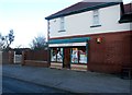
General Store in Royston
This traditional store and off-licence can be found on Station Road.
Image: © Jonathan Clitheroe
Taken: 14 Jan 2017
0.14 miles
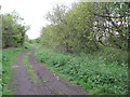
3
Who stole the bridge?
Bridge abutment from former railway bridge.
Image: © Steve Fareham
Taken: 19 Sep 2007
0.14 miles
4
![The edge of Royston [at the moment]](https://s0.geograph.org.uk/geophotos/03/21/94/3219432_98174b67_120x120.jpg)
The edge of Royston [at the moment]
Houses in Wood Walk, seen from the northern end of Melton Way. New estates east of Station Road are constantly eating into Low Common.
Image: © Christine Johnstone
Taken: 10 Nov 2012
0.15 miles
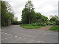
5
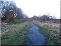
Path and Former Railway Line near Windmill Hill
Image: © Jonathan Clitheroe
Taken: 14 Jan 2017
0.15 miles
6
Notton & Royston railway station (site), Yorkshire
Opened in 1882 by the Barnsley Coal Railway, soon to be part of the Manchester Sheffield & Lincolnshire Railway, on the short line from Nostell to Stairfoot, near Barnsley. The station closed to passengers in 1930.
View south west along the trackbed, towards Staincross & Mapplewell. No trace of platforms could be found in the undergrowth.
Image: © Nigel Thompson
Taken: 19 May 2013
0.15 miles
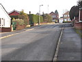
7
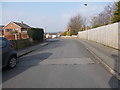
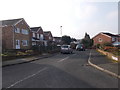
Ainsdale Road - looking towards Summer Road
Image: © Betty Longbottom
Taken: 14 Feb 2017
0.17 miles
8
Missing Bridge
The missing railway bridge used to carry the railway over Station Road. The trackbed is now a footpath.
Image: © Michael Patterson
Taken: 9 Mar 2006
0.17 miles
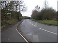
9
Guildford Road - viewed from Buckingham Way
Image: © Betty Longbottom
Taken: 14 Feb 2017
0.17 miles