IMAGES TAKEN NEAR TO
Fish Dam Lane, BARNSLEY, S71 3EZ
Introduction
This page details the photographs taken nearby to Fish Dam Lane, S71 3EZ by members of the Geograph project.
The Geograph project started in 2005 with the aim of publishing, organising and preserving representative images for every square kilometre of Great Britain, Ireland and the Isle of Man.

There are currently over 7.5m images from over14,400 individuals and you can help contribute to the project by visiting https://www.geograph.org.uk
Image Map
Images are licensed for reuse under creativecommons.org/licenses/by-sa/2.0
Notes
- Clicking on the map will re-center to the selected point.
- The higher the marker number, the further away the image location is from the centre of the postcode.
Image Listing (15 Images Found)
Images are licensed for reuse under creativecommons.org/licenses/by-sa/2.0
Image
Details
Distance
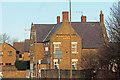
1
The home of Mr Kipling's cakes.
What was Lyon's bakery.
Image: © Steve Fareham
Taken: 14 Sep 2007
0.03 miles
6
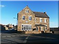
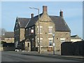
(Former) Wharncliffe Arms in Carlton
This public house which was converted into a private dwelling in 2016 although an original sign and crest survive. The latter represents the Earl of Wharncliffe who owned the local coal mines.
Image: © Jonathan Clitheroe
Taken: 14 Jan 2017
0.15 miles
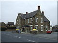
7
Wharncliffe Arms Pub
Standing on the corner of Fish Dam Lane and Shaw Lane.
Image: © Martin Lee
Taken: 13 Jan 2012
0.16 miles