IMAGES TAKEN NEAR TO
Beacon View, BARNSLEY, S71 2SW
Introduction
This page details the photographs taken nearby to Beacon View, S71 2SW by members of the Geograph project.
The Geograph project started in 2005 with the aim of publishing, organising and preserving representative images for every square kilometre of Great Britain, Ireland and the Isle of Man.

There are currently over 7.5m images from over14,400 individuals and you can help contribute to the project by visiting https://www.geograph.org.uk
Image Map
Images are licensed for reuse under creativecommons.org/licenses/by-sa/2.0
Notes
- Clicking on the map will re-center to the selected point.
- The higher the marker number, the further away the image location is from the centre of the postcode.
Image Listing (16 Images Found)
Images are licensed for reuse under creativecommons.org/licenses/by-sa/2.0
Image
Details
Distance
2
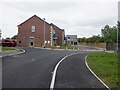
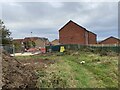
Folly Way
Newly built houses in Monk Bretton.
Image: © Richard Webb
Taken: 30 May 2023
0.07 miles
3
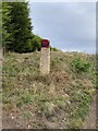
Odd painted marker on the way to Monk Bretton Trig Point
Image: © thejackrustles
Taken: 12 Oct 2021
0.07 miles
4
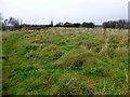
Monk Bretton
Parked on Byron Drive then used footpath to bag flattish highpoint and trig with Martin Richardson.
Name: Monk Bretton
Hill number: 16832
Height: 119m / 390ft
Parent (Ma/M): 2810 Black Hill
Section: 36: Lancashire, Cheshire & the Southern Pennines
County/UA: Barnsley (UA)
Class: Tump (100-199m)
Grid ref: SE 35946 07828
Summit feature: no feature: ground by track c 60m N of trig point
Drop: 36m
Col: 83m SE350092
Image: © Rude Health
Taken: 23 Nov 2014
0.09 miles
5
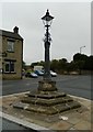
Old Central Cross by High Street, Monk Bretton
Monk Bretton Market Cross, old shaft, base and steps in a new cross, by the UC road, in parish of Barnsley (Barnsley District), High Street, Monk Bretton, at junction with Cross Street, on an island, opposite The Pheasant PH.
Grade II listed. List Entry Number: 1151147
https://historicengland.org.uk/listing/the-list/list-entry/1151147
Scheduled Monument. List Entry Number: 1013765
https://historicengland.org.uk/listing/the-list/list-entry/1013765
Surveyed
Milestone Society National ID: YSBA_BAR02
Image: © Alan Rosevear
Taken: 23 Sep 2012
0.13 miles
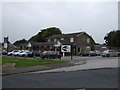
7
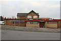
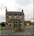
Full House Public House
Situated on the corner of Warwick Road and Rotherham Road is this Public House. The housing estate in close proximity is often referred to as the Full House Estate although most of the names are of writers.
Image: © Martin Lee
Taken: 31 Jan 2012
0.17 miles
8
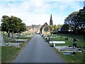
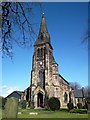
Monk Bretton Cemetery
The spire of St Paul's Church can be seen
Image: © Geoff Pick
Taken: 3 Oct 2009
0.17 miles