IMAGES TAKEN NEAR TO
Brettas Park, BARNSLEY, S71 1XU
Introduction
This page details the photographs taken nearby to Brettas Park, S71 1XU by members of the Geograph project.
The Geograph project started in 2005 with the aim of publishing, organising and preserving representative images for every square kilometre of Great Britain, Ireland and the Isle of Man.

There are currently over 7.5m images from over14,400 individuals and you can help contribute to the project by visiting https://www.geograph.org.uk
Image Map
Images are licensed for reuse under creativecommons.org/licenses/by-sa/2.0
Notes
- Clicking on the map will re-center to the selected point.
- The higher the marker number, the further away the image location is from the centre of the postcode.
Image Listing (8 Images Found)
Images are licensed for reuse under creativecommons.org/licenses/by-sa/2.0
Image
Details
Distance
1

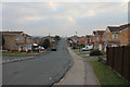
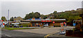
A635 to Wakefield
On the left is a new housing estate built upon land that once housed a depot/reapair centre for Blackwood Hodge.
Image: © Martin Lee
Taken: 31 Jan 2012
0.13 miles
2
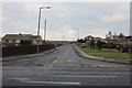
Burton Bank Road
Burton Bank Road is divided in two parts by a path up Burton Bank itself. New houses on the right are built on a former heavy plant repair depot called Blackwood Hodge.
Image: © Martin Lee
Taken: 31 Jan 2012
0.13 miles

4
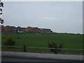
Westgate from the A635
This takes you up in the centre of Monk Bretton.
Image: © Martin Lee
Taken: 31 Jan 2012
0.16 miles

8
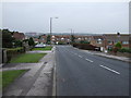
Finger licking good
On Wakefield Road Barnsley.
Image: © Steve Fareham
Taken: 13 Oct 2007
0.24 miles