IMAGES TAKEN NEAR TO
Rockley Meadows, BARNSLEY, S70 6RU

Introduction

This page details the photographs taken nearby to Rockley Meadows, S70 6RU by members of the Geograph project.

The Geograph project started in 2005 with the aim of publishing, organising and preserving representative images for every square kilometre of Great Britain, Ireland and the Isle of Man.

There are currently over 7.5m images from over14,400 individuals and you can help contribute to the project by visiting https://www.geograph.org.uk

Image Map


Images are licensed for reuse under creativecommons.org/licenses/by-sa/2.0
Notes
  • Clicking on the map will re-center to the selected point.
  • The higher the marker number, the further away the image location is from the centre of the postcode.

Image Listing (15 Images Found)

Images are licensed for reuse under creativecommons.org/licenses/by-sa/2.0
Image
Details
Distance
1
The Bush Inn, Kingstone, Barnsley
Image: © Peter Beard Taken: 28 Jun 2007
0.12 miles
2
A sad looking Bush Inn
Image: © Peter Bond Taken: 21 Apr 2013
0.15 miles
3
Flats off Broadway
Image: © JThomas Taken: 3 Oct 2014
0.20 miles
4
Broadway (A6133)
Heading south east.
Image: © JThomas Taken: 3 Oct 2014
0.21 miles
5
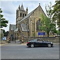
St Edward the Confessor's church
Image: © Chris Morgan Taken: 2 Sep 2022
0.21 miles
6
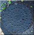
Cast iron drain cover
Circular manhole cover manufactured by Naylor Bros of Denby Dale. Located on the footpath on Keresforth Hall Road opposite Beech Grove.
Image: © Bobby Clegg Taken: 11 Aug 2024
0.21 miles
7
St Edward's Church on Keresforth Hill Road
Image: © Steve Daniels Taken: 22 Apr 2023
0.21 miles
8
St Edward's Church, Kingstone
Image: © John Slater Taken: 15 Nov 2014
0.22 miles
9
Footpath in Locke Park
Saturday morning and runners and supporters are arriving for the Barnsley parkrun. http://www.parkrun.org.uk/barnsley/
Image: © Graham Hogg Taken: 23 Jan 2016
0.22 miles
10
Locke Park
Image: © Mark Anderson Taken: 26 May 2013
0.23 miles