IMAGES TAKEN NEAR TO
Keresforth Hill Road, BARNSLEY, S70 6RF
Introduction
This page details the photographs taken nearby to Keresforth Hill Road, S70 6RF by members of the Geograph project.
The Geograph project started in 2005 with the aim of publishing, organising and preserving representative images for every square kilometre of Great Britain, Ireland and the Isle of Man.

There are currently over 7.5m images from over14,400 individuals and you can help contribute to the project by visiting https://www.geograph.org.uk
Image Map
Images are licensed for reuse under creativecommons.org/licenses/by-sa/2.0
Notes
- Clicking on the map will re-center to the selected point.
- The higher the marker number, the further away the image location is from the centre of the postcode.
Image Listing (3 Images Found)
Images are licensed for reuse under creativecommons.org/licenses/by-sa/2.0
Image
Details
Distance
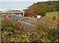
2
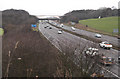
The M1 SW of Dodworth
Three forms of transport are represented here: the shot is taken from a railway bridge (albeit on a now defunct line), to the north is a road bridge over the motorway, and yet further north (and still just in the grid square) is a footbridge.
Image: © Chris Yeates
Taken: 4 Feb 2006
0.24 miles
3
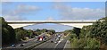
Arched pedestrian bridge over the M1
Image: © Dave Pickersgill
Taken: 18 Sep 2018
0.24 miles