IMAGES TAKEN NEAR TO
Green Lane, BARNSLEY, S70 6FN
Introduction
This page details the photographs taken nearby to Green Lane, S70 6FN by members of the Geograph project.
The Geograph project started in 2005 with the aim of publishing, organising and preserving representative images for every square kilometre of Great Britain, Ireland and the Isle of Man.

There are currently over 7.5m images from over14,400 individuals and you can help contribute to the project by visiting https://www.geograph.org.uk
Image Map
Images are licensed for reuse under creativecommons.org/licenses/by-sa/2.0
Notes
- Clicking on the map will re-center to the selected point.
- The higher the marker number, the further away the image location is from the centre of the postcode.
Image Listing (48 Images Found)
Images are licensed for reuse under creativecommons.org/licenses/by-sa/2.0
Image
Details
Distance
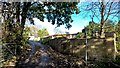
2
Horse stiles on the Trans-Pennine Trail, each side of a lane
The lane led to Rob Royd Bleach Works (Linen & Cotton). It is a public footpath, which has been diverted to the footbridge in Image
Image: © Humphrey Bolton
Taken: 30 Apr 2021
0.02 miles
3
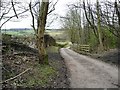
Lane running down to Green Lane and Brough Green
Dropping down [south-west] from the Trans Pennine Trail towards the east side of the M1.
Image: © Christine Johnstone
Taken: 19 Mar 2016
0.03 miles
4
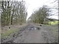
Trans Pennine Trail heading west towards the M1
This path was built as a railway to Silkstone Moor End, and later became part of the electrified Woodhead line, closing in 1981.
Image: © Christine Johnstone
Taken: 19 Mar 2016
0.04 miles
5
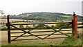
Field gate with Wentworth Castle in the background.
Image: © Steve Fareham
Taken: 2 Sep 2007
0.05 miles
6
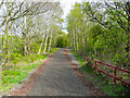
The Trans-Pennine Trail east of the M1, Dodworth
The trail here now has a smooth KBI 'Flexipave' porous surface, from Dodsworth to Worsbrough at least.
Image: © Humphrey Bolton
Taken: 30 Apr 2021
0.10 miles
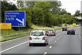
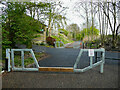
9
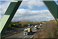
The M1 motorway
Looking north from a pedestrian footbridge
Image: © Graham Hogg
Taken: 10 Nov 2015
0.11 miles
10
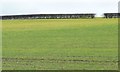
Gap in the hedge, west of Rob Royd Farm
An almost abstract landscape on the north side of the former railway line, now the Trans Pennine / Dove Valley Trail.
Image: © Christine Johnstone
Taken: 19 Mar 2016
0.12 miles