IMAGES TAKEN NEAR TO
Dodworth Road, BARNSLEY, S70 6EY
Introduction
This page details the photographs taken nearby to Dodworth Road, S70 6EY by members of the Geograph project.
The Geograph project started in 2005 with the aim of publishing, organising and preserving representative images for every square kilometre of Great Britain, Ireland and the Isle of Man.

There are currently over 7.5m images from over14,400 individuals and you can help contribute to the project by visiting https://www.geograph.org.uk
Image Map
Images are licensed for reuse under creativecommons.org/licenses/by-sa/2.0
Notes
- Clicking on the map will re-center to the selected point.
- The higher the marker number, the further away the image location is from the centre of the postcode.
Image Listing (28 Images Found)
Images are licensed for reuse under creativecommons.org/licenses/by-sa/2.0
Image
Details
Distance
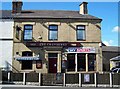
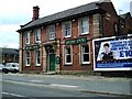
3
The Marlborough, Barnsley
On the corner of Lancaster Street and Dodworth Road.
Image: © Geoff Pick
Taken: 21 May 2009
0.08 miles
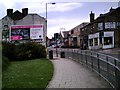
4
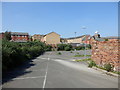
Springfield House Car Park
Springfield House Car Park as viewed from Springfield Street.
Image: © Darren Haddock
Taken: 25 May 2017
0.09 miles
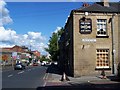
5
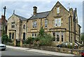
Grand old houses on Dodworth Road, Barnsley
Image: © Chris Morgan
Taken: 2 Sep 2022
0.11 miles
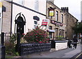
6
The Shaw Inn, Racecommon Road, Barnsley
Image: © Peter Beard
Taken: 28 Jun 2007
0.14 miles
7
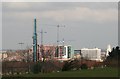
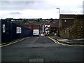
View of town developments from Broadway
Image: © Walking person
Taken: 17 Mar 2009
0.15 miles
10
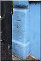
Benchmark #20B Racecommon Road
Ordnance Survey cut mark benchmark described on the Bench Mark Database at http://www.bench-marks.org.uk/bm39176
Image: © Roger Templeman
Taken: 13 Aug 2011
0.16 miles